|
|
Based on the paper by M Page & R Jones "Medieval settlements and landscapes in the Whittlewood area : interim report 2001-2" in 'Medieval Settlement Research Group Annual Report 16 (2001)', pp. 15-25 - with supplementary material from The History of the County of Northampton Vol.V - Cleley Hundred (ed. Philip Riden)
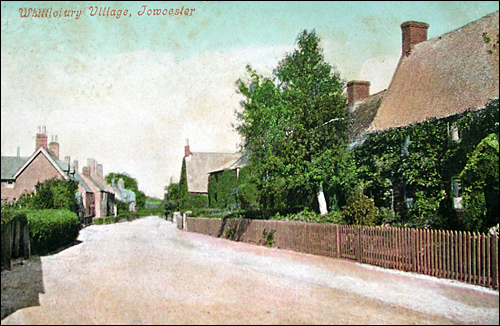
A Brief History of Whittlebury
Throughout the Middle Ages, Whittlebury, like neighbouring Silverstone, was a chapelry dependent upon the royal manor of Greens Norton, about four miles to the north. The ‘burh’ element of Whittlebury, compounded with the personal name Witela, suggests the presence of a hillfort held by a Saxon nobleman. The area was strategically situated on the border between the kingdom of the
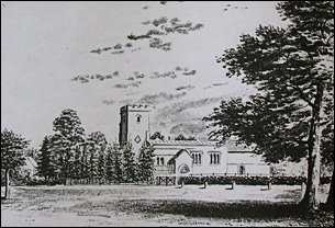
The origins of Whittlebury may thus lie in a hillfort, situated perhaps on the high ground in the enclosure now occupied by the parish church. Although there is no direct evidence to suggest that the place ever suffered from the depredations of marauding Danes, the Anglo-Saxon Chronicle makes clear that this was an area at risk of attack in the early 10th century. The site must, therefore, have been reasonably well defended, enough at least to serve as the venue for a royal council in 930. A defensive hillfort may also have acted as a focus for settlement, much as Norman castles were to do in the 11th and 12th centuries. Tenements may thus have been established in the shadow of the enclosure. Whittlebury is not mentioned in the Domesday Survey of 1086. It is possible that this was because the manor was subsumed within the account of one of the estates in Silverstone. In the 12th century it was reported that Richard held six small virgates in Whittlebury of the fee of Silverstone. Alternatively, the dependency upon Greens Norton may explain the manor’s absence from Domesday Book. In 1316 John son of William Marshal was lord of Greens Norton and its vills of Duncote, Burcote, Caswell, and Whittlebury. The earliest mention of Whittlebury’s chapel is in 1322.
It is likely that, as a detached part of the royal manor of Greens Norton, Whittlebury and Silverstone originally formed a single estate which was only later divided into two separate parishes. Evidence suggests that the links between the two communities and Greens Norton persisted into the 16th century. For example, an account roll of 1536 records that both paid an annual due called aberyes rent to the lord there. The links between Whittlebury and Silverstone were also strong. Indeed, the fact that both late medieval manors of Silverstone also encompassed parts of Whittlebury suggests that the parish boundary between them may only have been established at a relatively late date, perhaps in the 12th century. Although the courts held by Burnham Abbey and Luffield Priory were dominated by business concerned with Silverstone, sufficient references to Whittlebury survive for something to be said about the tenants there. First, numerous tofts existed in Whittlebury in the 15th century, suggesting a significant contraction of settlement there. Thus, in 1420 Thomas Walsh died holding a toft and two acres. In 1468 five tofts were listed in a rental of Luffield Priory’s lands, one of which was stated to be ‘formerly a cottage’, and William Hall held two tofts beside his messuage. Evidently there had been some consolidation of holdings in the wake of the Black Death. Second, while some tenants at Whittlebury in the 13th century held standard villein holdings of a messuage and virgate or half-virgate, others held smaller amounts of land such as a messuage and croft or a few acres. There was, therefore, a significant number of smallholders in Whittlebury who may be expected to have made a living in much the same way as their counterparts in Akeley. Third, as at Akeley, there were attempts by the absentee lords of Whittlebury to ensure that the tenants fulfilled their obligations to keep the roads clear, mend the weir, enclose the well, and prevent other nuisances.
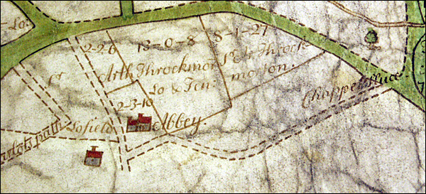
The entire parish of Whittlebury is depicted on the
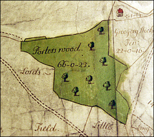
Two substantial farms in Whittlebury remained separate from the village and its fields. Lordsfields Farm lay in the north-western tip of the parish and was centred on a medieval moated site which still exists today (SP 687 450). The map of c.1608 depicts the second farm, Monks Field, lying to the north-east of the village abutting the border with Paulerspury. Monks Field was in the possession of Luffield Priory before the dissolution. In 1551 it came into the possession of Nicholas Throckmorton, along with other lands in the area which had belonged to the priory. Throckmorton had numerous holdings in and around Whittlewood Forest, and these were increased by his son Arthur as seen in the maps below.
Whittlebury was not part of the honor of Grafton, but the Dukes of Grafton had interests there as a result of their tenure of the rangership of Whittlewood Forest. There are a small number of rental properties which they held throughout the 18th and 19th centuries in Whittlebury and which are listed elsewhere in this section. A major change in the area came with the disafforestation of Whittlewood in 1853. Though Paulerspury was entitled to claim an allotment of land within the former forest as compensation for the loss of rights to pasture horses and cattle in the forest between May and September each year and also to collect firewood, when the allotment was made it was in Whittlebury parish, and was eventually acquired by the Grafton Estate. The changes accompanying disafforestation may be one reason behind the major fall in population shown in the graph at the top of the page.
Whittlebury was part of the Grafton Estate Sale of 1919. Porters Wood did not sell and was entered in the sale of 1920. The population had withstood the kind of falls in number in the 1880s and 1890s seen in so many other villages, though there were further falls in the 20th century. Despite increases after the second World War, there was a dramatic drop in the 1970s. The area remains very rural in character, despite the proximity of Silverstone race circuit.
|
||||||||||||||||||||||||


|