
 |
|
Extracts from: "The Story of Haversham" by Rev. Samuel Hilton, M.A. Rector of Haversham (Published in 1937)
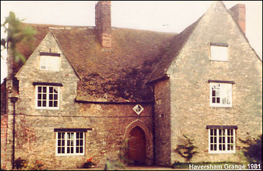
THE GRANGE A veil of mystery has long hung over the old building at the north end of the village, and least one strange story about it has been circulated, which has no foundation in fact. An attempt is here made to piece together what authentic information is available. Its story is connected with a certain parcel of land in the parish, which in the 13th, 15th and 16th centuries was called Ernesdene or Yernysden, and which had been given to the Abbey of Lavendon. Although no remains exist at Lavendon of this Abbey, it is known that John de Bidun built and endowed one there to the honour of St. Mary and St. John the Baptist about the end of the reign of Henry II, that is, before 1189, and that it consisted of 10 or 12 canons of the Premonstratenian order just before the dissolution of the monasteries. The first mention of Ernesdene does not happen to be in connection with the Abbey, but it is of help in locating its situation which is to the west of the parish and not far from the field called Lay Stockings. It will be remembered that this was one of the fields over which a test case was tried before King John in the year 1207. THE FINAL SETTLEMENT IN 1207 A.D. This is the final agreement made in the King’s court at Merleb’ge (Marlborough) on the 15th day after the feast of St. Martin, in the 9th year of the reign of King John, in the presence of the Lord King himself (and others named) …. Between Benedict de Haveresham petitioning and Hugh de Haveresham tenant, concerning 42 acres of land with appurtenances in Haveresham. One thing was agreed between them in the aforesaid court namely, that the aforesaid Benedict recognised the whole forementioned land with appurtenances to be lawfully Hugh’s own. And on account of this recognition and fine and agreement, the same Hugh gave and conceded to the same Benedict twelve acres of woodland, measured by the King’s perch, in the wood which is called Ernesden’ towards the west, and six acres of land of the same vill, measured by the legal perch, namely in Lauedistoking, to have to hold to himself and his heirs, of Hugh himself and his heirs alike, with a fourth part of a knight’s fee, which formerly he held of him in the same vill. And on account of this gift and concession, the same Benedict conceded to the men of Hugh de Haveresham himself along with his men of the same vill. That they should have the right to pasture cattle in Benedict’s own grazing land, which is called Ruggemore. And, for himself and his heirs, he remitted and quit-claimed to the same Hugh all right to pasture cattle, which he had or claimed to have in the park of Hugh de Haveresham himself. Ernesdene: the name is drived from the Old English words “erne,” an eagle, and “dene,” a wooded valley. It is probably in the neighbourhood of the fields called Arden Well. Lauedistoking: that is, a clearing surrounded by stakes. It is the present Lay Stockings, alongside the wood to the north of the Ridgeway. Ruggemore: from the Old English words “rugge,” a ridge, and “more,” a heath or waste land. It is the high ground which the Ridgeway crosses, and is probably somewhere about the field now called Rowditch. The Ridgeway and Lay Stockings rise to a height of 323 feet above sea level, or about 120 feet above the village. There are three fields known today as Arden Well, and evidently they cover the ground originally known as Ernesdene. In 1226 there is a record in connection with the “Abbatia de Lavindene” a gift of Nicholas de Haversham and Robert de Belauney to the Abbey of the whole wood of Ernesdene, and the land on which the wood is situated with what pertains to it (totum boscum de Ernesdene, et terram super qua boscus sedet cum pertinentiis). Thirty years later the Abbot of Lavendon obtained a licence to enclose the wood of Ernesden in the forest of Salcey with a dyke and hedge, to cut down the trees, and to cultivate the ground. The odd thing about this reference in Charter Rolls is that its location is said to be in Salcey Forest. Quite possibly this large forest, or detached portions of it, extended as far as the boundaries of Haversham parish seven centuries ago. “The steward of the forest on this side Trent,” at least, included this woodland within the Salcey forest area. It would seem that these lands are the 24 acres which Thomas de Britannia held in 1278 free of rental except a nominal one of 4d. and 1 pound of cumin, and 1d. to John de Haversham as well as 9 shillings “to God and the Church.” Another John de Haversham, who was a chaplain, obtained a licence in 1325 “for the alienation in mortmain (i.e., that it should belong to the Abbey for ever), to the Abbot and convent of Lavendon of 12 acres of land in Haversham in aid of the maintenance of a chaplain to celebrate divine service daily in the Church of the Abbey for the soul of the faithful departed. By fine of 20 shillings. This land would no doubt be in addition to Ernesdene and close to it. A hundred years pass over before any further reference to it can be found, and this time it is not so much a positive reference as a likely deduction. In her will of 1423 Lady Clinton requested that the seven priest, for whom she left a generous allowance for seven years, were to “have esement in the place called Hornes Place.” This place was evidently an appropriate establishment such as a religious settlement would provide. The field adjoining the Grange is today caller Corner Close without any obvious reason. Two hundred years ago it was called Corn Close. May it not originally have been Hornes’ Close? There is a straight path or track leading from the Grange direct to the fields called Arden Wells, which is about ten minutes’ walk away. In a record of the rentals of William Lucy about 1476 it is said that the “Abbot of Lavendon held one Grange called Erenesden, and paid one pound of pepper to the Lord of the Manor annually at Christmas.” A previous account of the parish which has noted this reference in “Rentals and Surveys” has mistaken the initial letter E. for G, to which it is very similar in the original writing, but not identical, and so the word has been wrongly spelt Grenesden. At the dissolution of the monasteries about the year 1536, all religious houses and their property were valued, and among the lands possessed by the “Monasterium de Lavenden” are found these entries. Lathbury & Havereshame, annual value £13 15s 0d Yernysden, annual value 33s 4d. The land at Havereshame was no doubt the 12 acres given in 1325. Such are the historical references.
There are also remains of an ancient dove-cote here, which was thus noted in 1923:- “Internally it measures 11 feet by 12 feet, and there are about 450 stone recesses. The lantern remains in the middle of the roof, and there are windows (possibly not all original), in the north, south, and east walls.” Unfortunately, it has now fallen into a very decayed condition. Its existence at least would seem to be further evidence of the monastic association of this place. The Grange Farm, with 196 acres of fields and 9 acres of woodland (including Lay Stockings, and part of the old Ruggemore, but not Ernesdene, is now in the possession of the Lord of the Manor of Little Linford, Mr. R. B. Knapp, and the present tenant is Mr. W. T. Keeves. An interesting question arises as to the probable association of the Grange with the Church. That there must have been some connection may fairly be taken for granted. The Chancel of the Church (33 feet long) is almost as long as the nave (40 feet) from which it is divided by a low archway, and it has the appearance of having been intended at the first for a religious community. It is thought too that in the Middle Ages the parish altar stood before the recess in the east wall of the nave, where the clergy prayer-desk now stands. We are left to imagine that the resident brotherhood, when coming to the Church for their devotions, would cross over the fields, and approach the churchyard by the old entrance, which is now blocked up, and so to the “Priests’ Door” on the south side of the Church. |
|||||
|
|
|