|
Adapted from Pattishall - A Parish Patchwork (ed. Richard Moss & Iris Illingworth)
A Brief History of Dalscote
The manor of Dalscote was one of the 45 manors which made up the original honor of Grafton in 1542 (see The History of the Estate). There is no mention of it in the settlement given to Queen Catherine in 1665, however. This may indicate that the manor proper was one of those traded away in the intervening period. Queen Catherine's advisors did however seek to reclaim some of the original honor, and it seems they may have had some success in Dalscote, at least as far as the village is concerned, since records from 1725 show that the Duke of Grafton owned the Closes in Dalscote - those areas of land behind and around buildings in the village.
|
|
|
Section of John Eyre's "Map of the County of Northampton" 1779
|
Dalscote, (also called at various times and on various maps and surveys Descote, Darlscott and Darlescote) is one of a number of settlements around Pattishall. Like several of the other small hamlets on the Grafton estate it depended on neighbouring parishes for essential features like a church and a school. For most civil and ecclesiastical surveys and censuses, Dalscote was counted as part of Pattishall and it is not a simple task to arrive at consistent data for Dalscote alone over the length of its history. However, in 1720 the numbers of households in the villages which made up the civil and ecclesiastical parish of Pattishall were as follows:
| Pattishall |
44 |
| Fosters Booth |
4 |
| Astcote |
24 |
| Eastcote |
34 |
| Dalscote |
14 |
The population in the area rose in the middle years of the 19th century until the downturn in agriculture in the 1880s and 1890s had its inevitable effect. In 1953, the children of Pattishall school did a survey of farms in the district. The results were:
| Place |
Farmers |
Labourers |
| Pattishall |
3
|
2
|
| Fosters Booth |
1
|
1
|
| Astcote |
6
|
3
|
| Eastcote |
5
|
3
|
| Dalscote |
2
|
3
|
The greatest change to the character of the area came with inclosure in 1771. The Duke of Grafton owned the old Closes in and around Dalscote, and in 1770 the Duke was petitioned by other principal landowners in the district to agree to inclosure, and this duly took place a year later. Following inclosure, consolidation and rationalisation, the Duke owned around 95 acres in the area, including the Dalscote township, closes and other areas of land created by the inclosure process. In the early 19th century the 4th Duke of Grafton increased his holdings across the whole area covered by the Grafton Estate, and by 1836 the figure for Dalscote had risen to 135 acres. The Closes appear to have been sold off in the latter part of the 19th century, because they do not appear in the Grafton Estate sales of 1913, 1919 or 1920 when most of the outlying areas of the estate were sold off.
|
|
|
|
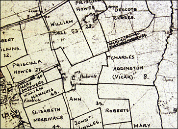
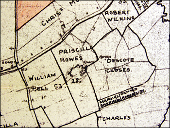
The Enclosures of 1772.
(l) a general view of the area, centred on Dalscote - (r) the Descote (Dalscote) Closes
|
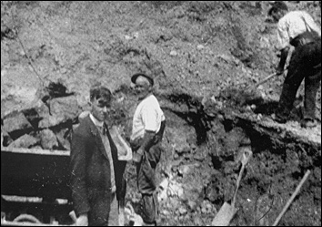
The final signficant development around Dalscote was the start of quarrying for ironstone in the 1850s. The growth of industry, railways, etc, fuelled a demand for iron, and attempts were made to exploit the deposits found in the Towcester and south-west Northampton area. Ore was transported by cart from open-cast mines at Gayton Wood to a railhead at Blisworth. The quarrying process continued into the middle of the last century. When the quarries were worked out and further use became uneconomic, the land reverted to the exclusively agricultural use which had characterised most of its history.
|