|
|
|
|
Strategic sites in Wolverton of important lost buildings
Sites which have lost defining landmarks, of historic importance for the development of the town. Some of these are occupied by replacement structures which damage local character. These are sites to bear in mind for:
a) redevelopment, better replacement structure
b) new landmarks or gateways
c) interpretation, marking or public artwork
Lost buildings, now sites with potential for a, b or c, or a combination, listed in chronological order:
| Building |
Treatment |
|
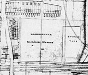
| 1. Site of the Works Square, which generated Wolverton town, built 1836-7 by George Aitcheson. On west side of present works access line, original line of London - Birmingham railway, opposite the railway front of the Triangle. Presently occupied by part of Tesco car park and Tesco filling station |
b or c. The Works Square could be marked out on the ground with explanatory interpretative board and/or a significant piece of public art |
 |
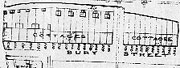
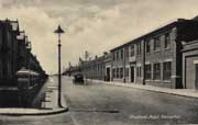
| 2. Site of Bury St, Cook St., Garnett St, Gas St and Walker St. 1835-7 under general supervision of George Aitcheson. On three sides round the Works Square q.v., i.e. on north , west and south sides of above site. Terrace housing in short streets. |
a, b or c |
 |
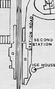
| 3. Site of the important second station and associated Refreshment Rooms 1840, either side of present Works access line to the south of Stratford Road bridge. McConnell Drive and Electrolux warehouse overlay the site. Road ramp to Secret Garden was originally created to give access to up, ie London, platform side of station |
a and c |
 |
| 4. The ‘Little Streets’ site of Creed St, Glyn Square, Ledsam St, Young St. 1840. 𠆋k-to-back’ terrace housing partly displaced by expansion of the Works, but largely demolished in late 1960’s ‘slum’ clearance and overlaid by industrial style shopping units, undistinguished and obsolescent council housing and obtrusive multi-storey BT exchange. |
a |
 |
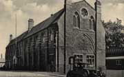
| 5. Site of Science & Arts Institute. 1861-64 by G.E.Street, extended 1880, 1891 and 1893. Destroyed by fire 1970. Important pioneering institution for ‘self-improvement’ and further education. Sited to south side of St. George’s Church, on site occupied now by car parking in front of former Wesleyan Methodist Church |
c |
 |
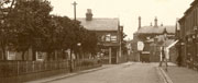
| 6. Central section of north side of Buckingham Street facing the Square and lost most mid-section of Radcliffe St c. 1870. Model housing and an important link in Wolverton’s grid plan. Site now occupied by Agora c. 1980. |
a - with opportunity to extend the Square to match the larger size of the surrounding town, re-open lost link with Stratford Rd, Church St and the Square, restore grid plan and rebuild a new market hall, shopping building addressing Church and Radcliffe Streets |
 |
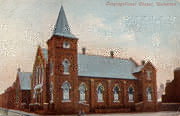
7. Site of Congregational Church 1878 by George Coker. South end of the Square. Demolished 1970. Now occupied by URC church on first floor above former Budgen’s supermarket, now Christian Foundation 1971, improved by conversion of supermarket for the Foundation 1990, but still generally considered an unworthy building for this important site, the focal point of the Square.
|
a |
 |
| 8. Site of original McCorquodale’s Printing Works 1878-1890s. Demolished 1988. Wolverton’s other important workplace, especially for women workers. On site of present car showrooms |
a and b. The original buildings formed a gateway building to the town and were several storeyed. Redevelopment could produce a new landmark/gateway building, perhaps primarily offices, possibly combined with some apartment housing. |
 |
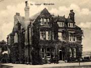
| 9. Site of the Gables, detached villa residence of C.A.Park, Works Superintendent. Demolished 1963, replaced by council housing and ‘tower’ block, none with any gables that were a feature of the original structure. Top of Creed Stand St George’s Way. |
a Potential for sheltered housing, building on and possibly replacing Orchard House, combined with urgently required nursing home accommodation. Place for a group, perhaps, of gabled buildings, something in the nature of a care village community. |
 |
|