|
|
© John Kliene, September 2002 - reproduced with his kind permission
"In 1582 William Gorges Esq. Built at Alderton a very mansion house, which falling to decay was in part pulled down by Mr. Rolte, the present possessor of it. By the part remaining which is embattled, it appears to have been a noble structure." This short description of the manor house of William Gorges was written by the antiquarian John Bridges during one of his visits to Alderton in the years 1719-1722. Gorges’ house no longer exists. The manor site is now occupied by a series of stone farm buildings converted into houses in the 1980’s, one of which, Bramblewood House, is now the home of the author. No plans or drawings of the house have so far been discovered but historical research and archaeological excavations have enabled a reconstruction of this forgotten Elizabethan manor house. Click here to see an interactive "Now and Then" animation of the Manor House History of the House According to Raymond Gorges, in his history of the Gorges Family, it was in 1567 that William Gorges Esq. purchased lands in Northamptonshire from Sir Christopher Hatton (Elizabeth I’s Chancellor of the Exchequer). Certainly at this time Hatton was building the largest house in
The Gorges The Gorges family trace their ancestry back to Ralph de Gorges, a
William Gorges’ father, Sir Edward Gorges, was High Sheriff of Somerset during the reign of Henry VIII and was, according to Raymond Gorges, knighted at the battle of
William had three distinguished brothers. Nicholas commanded the
William married Cecily Sparchford. Their union produced one daughter Frances. William is also known to have had one illegitimate son, William Wymesbank, to whom he bequeathed a farm and some lands from the Alderton estates. On William’s death, in 1589, he left his house and lands to
“One Ellen Sparchford, widow, and one Cicely, her daughter, wife of William Gorges Esq., deceased, now wife of Edward Fust, Gent, did 39 Elizabeth, confederate themselves with one Morris Lloyd, Gent, Richard Sparchford and others to dispossess James Bell of the premises, and on the 28th May last, with other riotous persons, men of lewd disposition, to the number of 12, and being armed with swords, daggers, muskets, calivers, pike staves etc., the which armour was made ready for them by Elinor Sparchford, Cicely Fust, alias Gorges, Richard Sparchford and others, did resort unto the said messuage, being a very house built of stone, and in most outrageous manner did and force open a great hole in the main wall, and struck out great bars of iron in the windows of the same house, whereby they made a passage for themselves into some of the rooms of the house, and there fortified themselves with great store of armour and weapons,- and finding some difficulties to enter arise further in respect of the great strength of the buildings thereof did continue together in the outward rooms of the same house by the space of three days, to the great terror and amazement of your Majesty’s subjects and inhabitants thereabouts……."
The Hesilriges The Hesilriges, whose name was changed to Hazelrig in the 19th century, have their family seat at Noseley Hall in Leicestershire, where the family still resides. Thomas was well connected in the Capital and apparently at Court. He was member of Parliament for Leicestershire and was knighted by King James I in 1608. This honour was bestowed on him when the King visited Grafton Manor. Four years previously, in August 1604, the King’s consort Queen Anne of Denmark, visited Alderton Manor where she stayed for four nights prompting speculation that she was present for some event, possibly an outdoor masque or play. These royal visits indicate that the manor house must have been of considerable size to cater for the royal retinue
Sir Arthur fought with distinction during the English Civil War, commanding his own cuirassier cavalry regiment. The 500 armoured cavalrymen, equipped at Sir Arthur’s personal expense, became known as the ‘Lobsters’ on account of their blue tunics and polished metal breastplates (cuirasses). After the war Sir Arthur was appointed Governor of Newcastle by Oliver Cromwell. During these years in the north of
Sir Arthur had married twice. By his second wife, Dorothy Greville, sister of Lord Brook, he had eight children one of which was named after his father. This Arthur Hesilrige was to marry Mary Longworth and inherit the manor house and estate in Alderton which he left to Mary on his death. Mary remarried in 1682 a doctor from Thurleigh in Bedfordshire.
Doctor Rolt It was Dr. Samuell Rolt that Bridges describes as possessor of the manor house when he visited Alderton. Rolt renewed the lease on the house in 1700 but demolished it.
The first known map of the village drawn in 1726 shows what is thought to be the remains of the house Bridges described (the large property marked 29 in the map above). By 1747 the site is recorded as derelict. Click here for the tree of the families connected with the Manor
George Baker, who wrote a history of the County of Northamptonshire between the years 1822-41, describes the manor house site as being occupied by stone farm buildings with the only evidence of the former manor house being the mullioned windows in the farm offices. Recent inspections by a number of building experts date all the windows to the 18th century or later but two do contain fragments of the earlier manor house.
Baker was describing Manor Farm which was acquired by the Duke of Grafton shortly after Rolt’s death in 1722. Manor Farm was managed by a number of tenant farmers through to the mid 20th century. In 1939 Manor Farm was part of the lands sold to the Hesketh family who sold them to a company of Stonemasons in 1984. The barns were then converted to luxury homes.
Reconstructing the House Since no plans or drawings have been found the task reconstructing an image of the house has had to rely on historical descriptions, the archaeological excavations which commenced in the summer of 2001, and expert advice based on known Elizabethan manor houses. Location Bridges described the location of the manor house as the
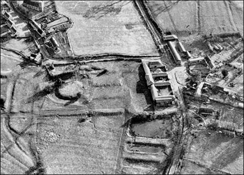
A black and white aerial photograph taken in the 1970s (see below) shows a rectangular cleared area of ground upon which the buildings of Manor Farm stand. The village map dated 1726, shows two large buildings occupying the site. These are thought to be the remains of the manor house described by Bridges.
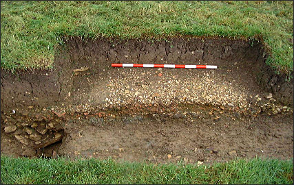
The approximate position can be calculated from all of the above evidence but with nothing of the original building still standing the only conclusive method to establish accurate position is that of archaeological excavation. Descriptions From Bridges we know the house was large, built of stone and embattled. That is to say it had a castellated roof. There are clues also from the description of the site in the proceedings of the Court of Star Chamber. The house is described as being ‘a very strong house built of stone’. There are references to the outer rooms of the house suggesting a courtyard layout and we are told the windows contained ‘great bars of iron’. The best description of the scale of the building and the rooms it contained come from two surveys of Alderton compiled during the Hesilrige ownership. The Parliamentary survey of 1660 describes the house follows: Mansion House consisting of a large Hall, a Parlour, two Buttereys, a Kitchen, a Pantry, two Larders, one Dining Room and several lodging rooms. One long gallery and divers chambers, one brewhouse, wash house and other necessary houses with one Barn, Oxhouse and stables lying in ye Cottage yard being twelve Bays of building. One large orchard, two garden ponds and a little pygtle lying over against ye said Manor house together with acres of arable land, 40 acres of furlonged ground and 20 acres meadow…. A second description dated 1650, but from the reference to Thomas Hesilrige suggesting an earlier date, has also be found describing the property: Site and capital messuage of manor of Alderton in township of Alderton now in tenure of Mr. Thomas Hezzlerigge, consisting of a large hail, parlour, kitchen, larder, two butteries, washhouse, slaughterhouse, with divers other necessary rooms below stairs, divers large lodging chambers over them, one fair dining room, two fair gardens, one large orchard well planted, with a large moat in the same, one dovecote with large stables, barns and other necessary outhouses cont. 12 bays, commonly called the cottage yards, being on the other side of the street, over against the house south. One close of pasture adjoining called Pond Close, lying on the backside of the house north, bounded by land of Mrs. Butler north, and the town street south, in all 6a. 2r. 24s. Archaeological Investigations In May 2001, under the guidance of Paul Blinkhorn, a local archaeologist, the author commenced excavations to determine the precise location of the manor house, its size and hopefully to learn something about its construction and room layout. To date eight trenches and two test pits have been dug. During the summer of 2001 the moat around the house formal garden path and the north wing of the house were found. The moat, the first discovery, is shallow being no more than one and a half metres in depth and must have had purely ornamental purposes. The moat contained manor house rubble and artifacts dating its infill to the late 17th or early 18th centuries. This is contemporary with Rolt’s demolition of part of the manor.
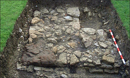
The garden path is almost 3 metres in width, cambered, and shows a three layered construction with a clay base, rammed roof tile hard-core and gravel top surface. Under the western edge a stone lined ‘V’ shaped drain was revealed. Pottery finds date the path construction to the late 16th century. In June 2001 the back lawn of the author’s home was dug revealing part of the manor house wall. The construction is of coarse limestone blocks on either face backfilled with smaller stones the whole being almost 1 metre thick. 11 walls were built upon a stepped foundation course in turn placed in a 2 metre wide construction trench. During the excavation of the accessible wall two chimney breasts were exposed, one with a largely intact flagstone fireplace complete with one of the iron fastenings for the firedog.
The northwest corner of the manor was found and this has a large ironstone quoin marking the corner. All of the dating evidence suggests the wall exposed is the north wall of the northern wing of the house and was demolished in the late 17th century. This wing does not appear on the 1726 map and therefore appears to be the part of the manor demolished by Rolt around 1700.
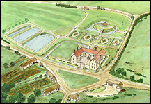
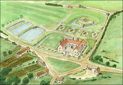
Excavations in the neighbouring garden to the east, Mull House, could not reveal the eastern extent of the house since it has been destroyed by the construction of a swimming pool in the 1980’s. The main trench dug at Mull House did reveal a backfilled cellar which must have lain under the east wing of the manor house. In 2002 two test pits were dug in front of Bramblewood House in an attempt to find further walls. One test pit contained a modern drain but the other exposed another backfilled cellar from which a high quality fragment of worked stone was recovered. This has been identified as part of an early medieval tracery window (1290 -1400). It is now thought that this find plus the other medieval confirm that Gorges built his house on the site of the medieval manor. The large building shown on 1726 village map may well be medieval lodgings which Gorges incorporated within his new manor. The Great Hall of such a building would have included tracery windows. Reconstruction After consulting with Elizabethan and medieval buildings experts and reviewing all of the evidence it is possible to put together a suggested reconstruction drawing of the manor house of William Gorges.
The house was probably of quadrangular plan. The east wing, which is considerably larger than the west wing on the 1726 village map, is interpreted as the remains of the medieval manor of Alderton to which Gorges added two wings. The northern wing was that demolished by Rolt. The western wing is the smaller building shown on the 1726 map. The wings were positioned around a courtyard closed to the south by an embattled gatehouse.
All of the wings were built from locally quarried limestone with ironstone quoins. The Elizabethan wings of the house had terra-cotta clay tiled roofs. Pale buff coloured roof tiles have been found which may have been made in Brill and could be part of the roof of the medieval lodgings. Abundant green Tudor window glass and fragments of lead cambe show the presence of leaded windows. Pieces of stone window frame with grooves for the leaded windows are built into the modern farm buildings; one piece was recovered from the moat trench. A variety of floor tiles have been found including black glazed and white painted types suggesting one or more of the rooms may have had a chequered floor. Some thought has been given to the arrangement of the rooms in the house and a virtual reality computer generated model is to be produced which will illustrate these ideas.
Earthworks from the formal gardens survive and with the help of Stewart Ainsworth, a landscape archaeologist, it has been possible to gain an understanding of their layout. Gorges used the fish ponds to the west as water gardens and he converted the motte (history under investigation) into a prospect mount. Terraces, the site of parterre gardens survive together with a perimeter walk, now feature within a modern golf course; part of the grounds
To the south of the house on the 1726 map a village green is shown. Facing the green on the south are a number of properties, some marked as belonging to Dr. Rolt. This must be the cottage yard referred to in the 17th Parliamentary surveys. The yard probably represents an outer courtyard for the house. At the southern edge of the green a trackway is shown entering this yard. This could be the main approach drive to the house which on 19th century maps is shown as a pathway.
Our understanding of the manor house built by William Gorges is now much clearer but there is still much that is not. None of the walls of the house other than the north wing have been revealed. It may be difficult to reveal more as modern buildings cover the site. A radar survey of the forecourt of Bramblewood House may tell us more about the size of the wings of the Tudor Manor. Historical research is also continuing on many aspects of the house and its history. |
||||||||||||||


|