|
|
Forests & Parks
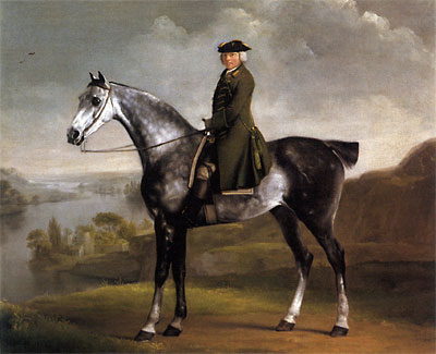
By 1705, the 1st Duke of Grafton (Charles II’s son by the Duchess of Cleveland) succeeded to the non-royal rights in Whittlewood including possession of Wakefield Lodge, which the 2nd Duke commissioned William Kent to rebuild. The Dukes bore titles of Lord Warden or Master Forester and were responsible for the supply of timber to the Crown; the upkeep of the forests and administration of forest laws; the custody and management of the deer and the supply of venison to the royal household. In practice, the day-to-day management of the forest was the responsibility of the Lord Warden’s Lieutenant and it was the 3rd Duke, Stubbs’ patron, who made Joseph Smyth his Lieutenant in 1747, two years after Bonnie Prince Charlie had fled these shores. Smyth maintained a staff of two Verderers, a Woodward, a Purlieu Ranger, five Keepers and six Page-Keepers and was in charge of the estate management, looking after both the Duke of Grafton’s and the Crown’s interests. In 1750 Smyth made a socially advantageous marriage to Lucy, daughter of Lucy Knightly, lord of the manor of Fawsley (the Christian name of Lucy was used by the males and females of this family). Thereafter, they lived at Sholebrook in the house now occupied by the Fenwicks. This striking portrait shows Smyth in his green greatcoat – the traditional colour worn by officers for vert and venison – looking eminently capable, on his fine grey horse, of discharging his duties efficiently and conscientiously. Smyth held his post for a remarkable 52 years and died in 1799. He lies buried at St. Mary’s Whittlebury. The Administration of Forest Law Forest Administration Northamptonshire Past & Present Vol. 5. No. 3 1975
The forest was the King’s, so senior officers were by royal appointment. At the head of the medieval administration were the Justices of the Forest. Deputy Justice for Whittlebury and Salcey was Justinian Isham. No records of Chief Justices are extant, but from scraps of evidence amongst private papers, it seems the Deputies developed their own ad hoc methods of dealing with flagrant transgressors. Wardens & Lieutenants On the local level the forest was administered by a complex system of medieval functionaries. Each forest was governed by a Warden, variously designated as Chief Forester, Master of the Game. He was usually a nobleman and had custody of the game and wood, with power to appoint and remove under-officers at pleasure. In Whittlewood and Salcey the wardens were appointed by Letters Patent for life until the time of Charles II, when the wardenship of Whittlewood was granted in reversion to the Dukes of Grafton, and of Salcey to George Montagu of Horton and his heirs forever. Each Warden had a lieutenant who was responsible for the routine administration of the forest. Such lieutenants again differed in rank and distinction. Members of the Wake family held the office in Salcey during much of the seventeenth century; in Whittlewood a keeper, one of the lesser gentry, held it. In Whittlewood and Salcey the lieutenants retained a real executive authority throughout the seventeenth century. Keepers Whittlewood and Salcey had a keeper of yeoman rank for each walk with page keepers to assist for double walks. In all private woodlands within the forests the employment of private woodwards was obligatory. They were essentially similar to the keepers in swearing to protect the King’s venison and in attending the swanimote. Rangers The institution of the purlieus had resulted in the appointment of mounted foresters, called rangers, to supervise straying deer and drive them back into the forest. Whittlewood in the mid-seventeenth century had a ranger and sub-ranger. The office must have disappeared, for when the Duke of Grafton appointed a purlieu ranger in 1766 it was criticized as an innovation. Verderers The elaborate organization to preserve the vert and venison included other minor offices such as bedel, bowbearer and clerk or steward of the swanimote, as well as two more important classes of officials – the verderers and regarders – whose duties were more of a judicial nature. Regarders
Twelve (or more) regarders were appointed by the sheriff for each forest or bailiwick. Strictly they should have been knights living within the forest, but they were almost invariably gentlemen. The regarders were sworn to make a triennial ‘regard’ or inspection of the forest, including private as well as royal demesne woodland. The keepers might attach offenders caught redhanded but the regard was intended to make a comprehensive check on all trespasses and abuses by other forest officers as well. Keepers and woodwards were to lead the regarders through the whole forest to investigate offences according to a list of ‘chapters of the regard’. Private Woodwards Agents for making surveys and sales of wood, estimating repairs of lodges, inquiring into waste and spoils, or reporting to the Treasury on particular problems connected with woods. Woodward
In the late 17th century, the woodward was a keeper, or even lieutenant and keeper of Whittlewood. In Tudor times the county woodward had a salary of only £5 (later £10) per annum, which was supplemented by a commission of fourpence on each tree marked for sale and a shilling in the pound from buyers as poundage on all woodsales. In 1696 the woodward was granted £30 in lieu of poundage. Preservator
Preservators were to be concerned with the forest as sources of wood and timber rather than games preserves. Keepers The keepers’ ancient wages were also meagre, often only £2 - £12 per annum, so they had to subsist on perquisites in the form of deerskins, browsewood and trees fallen by wind or vermin. In Whittlewood and Salcey the mixture of discordant interest was more conspicuous. After the Restoration woodwards’ and keepers’ abuses became so flagrant that warrants for the felling of timber were temporarily addressed to reputable local gentlemen and the business was supervised by the Surveyor General of Woods in person. As Sir Charles Harbord, Surveyor General of Crown Lands, lived at Grafton Regis he also exercised a personal supervision. Prison A deponent in 1610 mentioned a detail of antiquarian interest by referring to the forest prison at Moor End, a hamlet of Potterspury. If the prison had lost its importance with the relaxation of forest law, the forest villages had grown and were virile communities. These were divided into ‘in-towns’ and ‘out-towns’. The main distinction seems to have lain in the restriction of the latter’ common rights to a shorter period annually. X7206 Whittlebury Collection Vol. II Northamptonshire Gardens Trust Deer Parks
Deer folds or parks existed in Saxon times, but it was the arrival of the Norman aristocracy with their love of hunting that led to the creation of great numbers of deer parks in England. Northamptonshire’s earliest recorded parks – at Higham Ferrers, Moulton and Wicken – date to before 1200, but the peak of deer park construction was between 1200 and 1350, a time of national prosperity. A combination of available land (many Royal Forests were sold off to finance frequent wars) and readily available labour (under the feudal system) led to the creation of about 50 new parks in Northamptonshire alone. Park – from the Old English word “pearroc” meaning an enclosed field or paddock surrounded by a fence. The medieval deer park was an area set aside for hunting and management of deer and other animals. Unlike Royal forests, deer parks were relatively small and had clearly defined and securely enclosed boundaries. “William set aside a vast deer preserve and imposed laws concerning it … he forebade killing of harts, for he loved tall deer as if he had been their father” Anglo-Saxon Chronicle 1072 A.D. William I established large areas of land (woodland, farmland, villages and wasteland) as Royal Forest and all wild deer and hunting rights belonged to the Crown. Parks could not be bought or sold, they were gifts from the Crown since a licence to impark was granted as a favour for services provided or in return for loans. Created by the lord of the manor – royalty, ecclesiastical or lay nobility and later, the newly enriched landowners or merchants – deer parks were an important part of the medieval economy. Not only did they allow their owners to indulge their love of hunting but they were also a “living larder” providing a live game larder when, because of lack of winter feed, most animals had been slaughtered. Deer can survive as do rabbits and pigeons. Additionally they were places of social intercourse and, of course indicators of status. Owners were also able to give gifts of venison which were very common from the 15th to the 19th century. The King or Lord was the main participant in the hunt, but it was lead by skilled professions. Trained dogs such as greyhounds were used to take the deer or nets were used to capture the deer alive. The following payments were made regarding carriage of greyhounds also a grant to John Evan – falconer. 1528 11th September For a cart to carry the hounds from Grafton to Amptill after 15 miles 2s.-6d. 1532 29th July To Humphrey Raynez removing with the cart with hounds from Amptill to Grafton 2s.-6d. 7th Oct. 1539 Royal grant to John Evan, one of king's falconers, at Grafton In the late 15th, & 16th centuries many new “Tudor” deer parks, as at Grafton and Hartwell were created. These new parks were more of a status symbol acting as a decorative settings for their newly built country houses.
A letter written in 1575 while the Earl of Leicester was staying at Grafton with Queen Elizabeth I.. James I stayed at the Manor at Grafton in 1608, 1610, 1612, 1614 and again in August 1616, indulging his consuming passion for hunting deer, which was noted by the Venetian ambassador: ‘He seems to have forgotten he is King except in his kingly pursuit of Stags to which he is foolishly devoted.’ In 1605 Plum Park was enclosed and united with the two larger parks of Grafton and Potterspury to the west, when the total perimeter of the three was said to be eight miles; three years later a payment of £333 9s. 0d. was authorised to Thomas Hasilrigg, then lessee of Alderton demesnes, for woodlands to be added to Grafton and Potterspury parks: and in 1611 Sir Arthur Throckmorton and other tenants in Paulerspury were paid £50 for ground conveyed to the king for enlarging Grafton Park. The effect of these changes was to create a single estate which extended from Watling Street in the south-west to the Northampton road at Grafton, bounded on the north-west by the common fields of Alderton and Paulerspury, and on the south-east by those of Grafton and Yardley. These boundaries, probably established by 1620 if not a little earlier, remained unchanged until well into the 19th century. The estate as a whole was known as Grafton Park, although the distinction between Grafton Park and Potterspury (or Pury) Park survived well after the land itself had been disparked. There were two principal houses on the estate, Grafton Lodge and Potterspury Lodge. Both lodges are shown on a map of the Grafton Park estate of 1721. At Potterspury, the lodge lies within the inferred boundary of the medieval park but the present Grafton Lodge Pic Grafton Lodge brick pattern stands on the 16th century extension to the park. Repairs to the lodge at Grafton and to both parks were specified among work done at the honor of Grafton in 1619, and in 1637 Charles I was advised that the ‘Great Lodge’ in Grafton Park was so badly decayed that it would be better to take it down than repair it. The paling of both parks was in urgent need of attention to safeguard the deer, for which 100 oaks and £60 would be needed. Sir Charles Harbord, the Surveyor-General of Woods and Forests, was to be given the money and was himself to give orders to fell the trees needed for the work. The following year, another 70 oaks were still needed to complete the repairs at Grafton which were to be obtained from either Whittlewood or Salcey forests. Coppices in Grafton Park were regularly felled and sold in this period. Grafton and Pottespury Parks remained part of the honor of Grafton until the reign of Charles I and a succession of courtiers received grants of the keepership of the two parks, with a fee of 2d. a day, plus herbage (right of pasture on another’s land), pannage (right of pasturage of pigs to forage for acorns and beechmast in the woodland) and fallen wood. From 1622 to 1628 the office was held by George Villiers, Duke of Buckingham, the powerful favourite of James I and Charles I. he was succeeded by Sir William Washington and his wife Anne, while the earl of Dorset held the office of high steward of the honor of Grafton. By 1633 a fresh grant was made to Sir Francis Crane and Anne Washington with reversion to Dorset. Crane was at this date involved in negotiations to lend £7,500 on security of a mortgage of the honor. As Charles I’s financial problems worsened in the 1640s, the Grafton Park estate was seen as a convenient means of raising further sums. In 1641 the King made a grant to Thomas Marsham and Ferdinand of London of the office of keeper of Grafton and Potterspury parks for life, with the usual stipend of 2d. a day and right for herbage and pannage, and the browse wood (young shoots as fodder for cattle). Windfalls and dead wood, with the reversion of the offices to the Earl of Dorset By 1700 however, population growth and the demand for land, the ravages of the Civil war and the Crown’s need for income led to the decline of deer parks – they fell into disuse, reverted to woodland or were sold off and converted into farming land. DEER PARK MANAGEMENT Deer parks were usually established in open countryside, on marginal land and at some distance from the manor house or estate centre. They varied in size – twenty acres at Stoke Bruerne to several hundred acres at Grafton Regis. The deer park owner had to make sure that it was securely enclosed so that the deer could not escape. Deer can leap up to 6 metres horizontally and 3 metres vertically so this involved the building of a substantial boundary or “pale”. The pale consisted of a wide internal ditch and large earthen bank topped with a wooden (oak) palisade or occasionally a hedge or stone wall. They were designed to allow the deer to run up the ramp and jump into the park, but they could not do the reverse trip. Such boundaries were expensive to build and maintain. Most early parks were circular or ovoid in shape – minimising the length of pale needed whilst maximising the area enclosed. Owner also took advantage of natural boundaries such as water, steep cliffs or marshy land.
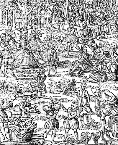
Occasionally the park pale may have been interrupted by a deer-leap (see picture above) This enabled deer to enter the park but prevented them from leaving it. Permission to create a deer-leap had to be granted by the Crown – a prized expensive privilege. William de Ferrers had one in his park at Potterspury. Inside the pale, there were wooded and grassed areas. The trees provided cover for the deer and a forest ambiance whilst the laundes (lawn) provided fodder. Ponds or streams for drinking water were also needed and in line with their role as a living larder, deer-parks often contained other features such as a fishpond , rabbit warrens and decoy ponds. A park keeper was usually employed to oversee the running of the park. He may have been provided with a house or lodge within the park. These could also be used by the owner and his entourage when hunting. Note:4th August 1532 To lord Ferrers' servant for bringing an angle rod to the king at Grafton 15s. Evidence for deer parks in the county varies greatly – the park interior often became agricultural land/ woodland pr part of a later ornamental park. The medieval park’s shape may be “fossilised” in later field boundary patterns. The park pale or parts of it my survive as a substantial earthwork ditch and/or bank or it may have been eroded and reduced in scale Where the earlier palisade was replaced by a stone wall. John Morton’s The Natural History of Northamptonshire 1712. Evidence may exist in the form of field or place-names, such as Park Farm. The Lawn or Lodge, which hints strongly at the location of a medieval deer-park. In these categories falls our local parks at Paulerspury, Potterspury, Grafton and Hartwell, which linger on in the names of Farmhouses and Lodges. One of the problems keepers of the parks had to contend with was the perennial poaching. The identification of the offenders was not always clear. The brothers of the Hospital of St. John of Jerusalem were accused in 1207of having greyhounds without licence of the king and they took a red deer in the park of Blaculuel (Blakesley). Northamptonshire Past & Present Vol. 5. No. 3 1975 PARKS Grafton Regis Park, part medieval and extended by Henry VIII, Potterspury Park dating from 1230 and Plumpton Park founded by Richard Damory in 1328 all share common boundaries and all are on the edge of the arable fields which surrounded the villages of Paulerspury, Yardley Gobion and Grafton Regis. GRAFTON PARK Grafton Park was part medieval and part Tudor and within it Pettit recognised that the long curving sweep of an existing hedgerow aroused suspicion of the pre-inclosure origin-part of the medieval boundary before the enlargement of Henry VIII. To enhance his pleasure when hunting at Grafton on his annual progress Henry VIII included within the honor a system of parks which he had enlarged or newly imparked. This was done at Grafton in 1532 when the king took 76 acres from the fields of Grafton and 70 acres from Alderton. It was described by Leland as being inclosed partly by pales and partly by a quickset hedge. In 1558 it was estimated that there were 500 deer in Grafton. James I enlarged the park and the Crown retained it in 1628. In 1644 Charles I sold Grafton and Potterspury parks to Sir George Strode and Arthur Duck, with liberty to dispark them, for £7,000 and in the 1660 survey it was reported that “The Lord Mounson hath cut down all the trees in Pury Park and the greater part of those in Grafton park to his own use. HANDLEY In 1220 John Mar and Hugh de Neville were commanded to enquire whether meadow and pasture between the king’s park of ‘Hanle’ and the river Tove belonged to the Countess of Essex’s manor or to the said park of Hanle. In 1236 John de Nevill, justiciar of the forest, was ordered to hand over to ‘Advocato de Bethun’ 6 bucks and 2 stags in the forest of Whittlewood, and in the park of Handley 2 bucks by the gift of the king. Hugh of Goldingham was ordered to deliver to the Prior of Luffield 10 oaks from the royal park of Handley to build the roof of the monastic church (Cal Close R.1264-8). The keeper of Handley was also ordered to provide the sheriff of Northampton with 3 oaks for finishing the kitchen of the royal house at Silverston. (Cal Close R.1268-7)2. Elias de Tyngewick was both keeper of the forest of Salcey and the park of Handley Park, was ordered to allow the Friars preachers of Northampton 9 oaks from Salcey forest and of 6 oaks from Handley Park (Cal Close R. 1264-8) The perambulation of the forest in 1299 included the park of Handley within the old foss. Charles I in 1631 in consideration of the sum of £6,000, granted and gave up the premises, with several adjoining coppices in the forest, containing in all 863 acres to Sir Simon Benet of Beachampton. HARTWELL 25 acres of this park were medieval and the remaining 232 acres were imparked by Henry VIII who in 1531 required Sir John Mordaunt to write to the officers of Salcey forest and Moulton park commanding them to deliver to John Hartwell and Richard Wale “such and as many oaks, convenable for posts and rayels, and the lops and tops of the same” as shall be “sufficient for enlarging the park at Hartwell, and making a new lodge there” In 1564 there was 25 forest acres (presumably the original area of the park), and 460 oaks. In 1629 it was “disparked for ever as well from vert and hunting”, and sold to Endymion Porter for £2,100 and a £10 rent but the timber was reserved and sold later for £469 16s. 8d. It was later held successively by Sir Robert Berkley and Sir Francis Crane. MOOR-END Thomas de ferrers was granted a licence to crenellate his dwelling place of la Morende and to impark a plot of land and wood adjoining the said dwelling place (Cal. Pat. R. 1345-8) The Place Names of Northants. mentions a Moor End ‘La Mora’ in 1168 in Yardley Gobion. There is a moated site here and this may well be the site of the park. A deponent in 1610 mentioned a detail of antiquarian interest by referring to the forest prison at Moor End, a hamlet of Potterspury and the site of a medieval castle used by Edward III when hunting in Whittlebury2 PAULERSPURY In 1363 John de Pavely was allowed to convert his woods called Ottewood and Farnsted, containing 17 acres into a park. In 1410 John St. John knight, was said to have two parks in Paulerspury “called Oldepark and New Parke between which the said John has a farm called Framsted and 100 acres of land and a wood adjoining the said field and Oldparke called Estull and Outewodes containing 100 acres of land”. He was allowed to enclose the two parks, the field and the wood and make them into a deer park (Cal Charter R. 1314-1417) This seems to refer to imparking at the expense of arable and may well be the result of land going out of cultivation with the agricultural contraction of the 15th century. Bridges recalls(i 311) “at the corner of this park at a place called Benches in Whittlewood forest was formerly held the Swainimote Court for the said forest”. In 1541 it was alienated to the Crown. Ten years later it was granted in soccage with free warren to Sir Nicholas Throckmorton. In 1639 Lady Mary Woolton paid £100 for its disafforestation, and in 1673 the park still contained 77 acres of woodland and 5 closes of pasture reserved for deer. The remaining pasture had been divided into closes and leased at annual rents to local farmers. PLUMPTON PARK In 1328 Richard had licence to impark his woods of Plumpton Pirye in Northamptonshire, “although it was within the metes and bounds of the forests of Whittlewood before the perambulation made in the late reign” (Cal Pat R. 1327-30), Baker states that the name is retained in a small public house called “Plumb Parker Corner” and between 80-90 acres adjoining the property of Sir C. Mordaunt, Bart. Still retaining the name The Park. The bounds of Plum Park are seen in the c,1720 map of Grafton Park (N.R.O. map 4211 G 3804). A pronounced linear band about 20 feet across and 3 to 4 feet high with a dense tree cover remains on the northern and north-western sides south of Pury Hill Farm. SILVERSTONE Hugh de Neville was ordered to allow the prioress of Catesby 10 pieces of timber in the forest of Silverton outside the park of the king for the upkeep of her church (Cal Close R. 1227-31) It seems that the park was near the site of the king’s house at Silverstone. John Byset, justice of the forest, was ordered to allow the men of Silverstone to have herbage in the park of the same manor (Cal Close R. 1237-42). STOKE BRUERNE In 1270 Pagan de Chaworth had licence to enclose his wood and make a park. Pettit describes the park as wholly imparked by 1541. In 1564 it consisted of 91 forest acres, 108 statute acres, 53 acres of saleable coppice but no oaks. Stoke Bruerne park was granted with deer to Sir Francis Crane, a royal creditor, with an annual rent of £50 reserved c. 1628. The park lies within one mile of the Queen's house of Grafton and was wholly made in 1529/1530. The Royal Forests of Northamptonshire 1558-1714 by P.A. J. Pettit SALCEY
Salcey-originally meaning ‘Willow Wood’ – consisting of only 1,100 acres of coppice surrounding Salcey Lawn with its ancient ornamental oaks, making a total area of 1,847 acres. The forest was divided into four walks - Hanslope, Piddington and Hartwell in order of size, with Lawns comprising the Deputy Ranger’s Walk. Rights of common in Salcey were possessed by six forest villages, being Ashton, Hackleton, Hartwell, Piddington, Quinton and the large Buckinghamshire village of Hanslope. No perambulation of 1641 can be discovered and its doubtful whether one was made, but the Edwardian perambulation give approximate ideas of its meets and bounds. (A walk was a district of the Forest under the oversight of a Keeper.) NRO ML114 NRO ML 114
WHITTLEWOOD FOREST
Whittlewood or Whittlebury Forest extended from Syresham to Old Stratford and its total area exceeded 6,000 acres, of which over 4,500 acres were woodland. In 1608 Hazelborough Walk skirted Silverstone to the south and west; this village was the site of a medieval royal hunting lodge, yet it still retained its exuberant and unsophisticated forest character into the twentieth century. The western end of Hazelborough was sometimes known as Hazelborough Park while the eastern section consists of woods which were attached to the manor of Silverstone and were often leased out independently of the rest of Whittlewood, for example to the Throckmortons of Paulerspury or to the Earl of Bathurst. Then Sholebroke Walk - know as Norton Woods in the sixteenth century - separated Whittlebury from the two Lillingstones over the county boundary, but also had a promontory jutting north to Porter’s Wood. Both Sholebroke and the adjacent Wakefield Walk were large enough to be called double walks. The most striking feature of the latter was Wakefield Lawn, enlarged about 1600 and totally encircled by woods. The Lawn was overlooked by Wakefield Great Lodge, a royal hunting lodge under the Angevins1 which became successively the residence of a keeper, then of the lieutenant of the forest, and finally after a costly restoration in 1745, of the Dukes of Grafton, Wardens of Whittlewood. A south-eastern projection of Wakefield Walk towards Deanshanger was severed in Elizabethan times to constitute Hanger Walk. At the eastern extremity of the forest, the assarts of Puxley made the small Shrob Walk entirely detached from the belt of woodland. Another detached walk. Handley, lay to the north between Silverstone and Towcester. The exact status of this 860 acres of coppices and pasture was disputed in 16103 after some underhand scheming between the keeper and the Master of the Game. Although it had popularly been called a ‘park’, had been inclosed half a century earlier, and was not subject to commonable cattle, its status as a walk of Whittlewood was then proven. Each walk was encompassed by a ring-mound, still partly visable; Hazelborough alone was the exception and this allowed deer and commonable cattle to stray through the streets of Silverstone even in the nineteenth century. 1.See Brown , Colvin and Taylor, The history of the King’s Works, I, 83-4. 120; 11. 1006 2. E. 134/6 Jac I/Hil 4. Deposition of William Burte; for Edward III’s connection with Moor End, see Brown, Colvin and Taylor, The history of the King’s Works, ii, 742-5, Baker, op. cit., ii 82, states that a common prison for Salcey and Whittlewood existed at Hartwell-Wyck in 1280. 3. E.134/6 Jac I/Hil 4. deposition before Special Commission. The 1608 maps referred to from this page are NRO Map 4210. |


|