 North Crawley – A Brief History
North Crawley is a village and civil parish in the Borough of Milton Keynes, Buckinghamshire, England. It is located near the border with Bedfordshire, about three and a half miles east of Newport Pagnell.
The original name of the village is Great Crawley (Crawley Magna), and Little Crawley (Crawley Parva). They combined in Tudor times to become North Crawley, which would be the village and hamlet together, so technically the main village is still called Great Crawley. The village name is old English Crauli / crowe (crow), and Leah (clearing). The full development of Great Crawley occurred soon after 1128, under the expansion policy of King David of Scotland, Earl of Huntingdon.
North Crawley dates back to before the Domesday Book compiled in 1086, in which reference is made to only three churches existing in Buckinghamshire prior to the Norman Conquest; St Rumbold’s in Buckingham, St Osyth’s in Aylesbury, and St. Firmin’s in North Crawley.
The Grade 1 listed St. Firmin’s Church owes its foundation to a small religious house at Hardmead, which had been built by monks from France and dedicated to St. Firmin, the first Bishop of St Amiens. This dedication was carried on by North Crawley Church, and there are only two other churches in Great Britain dedicated to this little known saint who was martyred in AD 287.
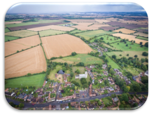
North Crawley is one of those parishes where a complicated system of land ownership over the years has ensured that the pattern of small, hedged fields, close to the village centre has survived almost intact since the time of the Enclosure Awards in 1773. The further away from the village, the larger the fields, which are remnants of the ancient open field system, this predominated over the areas to the west and south-west of the village. As a result, there is today a pleasant mixture of pasture and arable land surrounding the village.
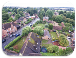
The development pattern of settlement in the parish was dispersed with a number of ‘ends’, typical of a woodland settlement. The church and three farms were located at the centre together with many smaller ‘home closes’ clustered around the village street. Church Farmhouse, a Grade II listed property just east of the church, was one of the early farms. Several manors existed in the parish, including three with moated sites, for example Grade 2 listed Moat Farmhouse on Chicheley Road. Mathias Manor was the basis for the present day Grade 2 listed Crawley Grange, off Pound Lane. Haudlo Manor was replaced by the present Grade 2 listed Old Rectory in 1800.
Modern day North Crawley sits elevated above the surrounding landscape and is partially screened from view by trees. Approaching by road one is first aware of the church, sitting higher than the houses around it and visible amongst the trees. Within the village is a Victorian school, which lies adjacent to the church grounds, on the west side. The school was enrolled on 28th May 1844, it was jointly built by the Rector Thomas Selby Lowndes and Thomas Alexander Boswell, and was subsidised by a Parliamentary grant.
There are late Georgian and Victorian houses of varying size along the High Street with some older labourers’ terraced cottages and conventional, standardised 20th century houses here and there, testifying to a move away from the need for a local labour force to dormitory village serving the new town of Milton Keynes.
Standing opposite the entrance to Pound Lane is a former Congregational Church of 1821, built of local brick but with a carefully proportioned frontage comprising a central arched doorway with an arched window to each side and two more above.
The lanes and paths by which some parts of the village are reached are an important component of the village’s character. They invite exploration of the settlement on foot by which means the settlement slowly reveals both itself and important views of the church, which dominate the village, as well as views across attractive garden spaces and out into open countryside on the south side
In combination, the older buildings, their materials and details, the enclosed spaces created and the views through and out, often with mature trees forming a backdrop, create a harmonious and distinctive settlement pattern and a strong sense of place, both reflecting and documenting the underlying geology and the local craft skills that brought it about.
To the north of the village is an orderly but standardised late 20th century housing estate which does not contribute to the historic local character but it does provide a pleasant, and desirable residential area characterised by a mix of dwellings with large curtilages and an abundance of public open space. Whilst it all but doubles the size of the village, it is largely hidden from view as one passes along the High Street.
The road that cuts through the village is a local road between Tickford End, Newport Pagnell and Cranfield. This is a popular back road, and at certain times of the day the village roads can become congested as traffic makes its way through the village.
The expansion in housing and the popular route provided by the road may explain the continued presence of a school, shop and two pubs in the village, all of which provide important, ongoing day time activity.
Despite the presence of some unsympathetic late C20th and C21st developments and a growing prevalence of more modern materials the sense of a well preserved, traditional rural village is still strongly discernible.
More recently a Village Plan for Development has been passed by a village vote and adopted by Milton Keynes Council.