A Circuit of the Village taking about 1 hour—3 miles
If you do this every day you will have walked over 1000 miles in a year.
START
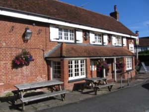
At the space used by The Cock as its car park, locally called “The Waste Ground” a medieval term for unused land which has been used in the village for centuries, and sometime in the past was part of St.Firmins Churchyard, as bones have been discovered when water tanks were installed.
Behind you is St. Firmins Church , in the Doomsday Book of 1086 there are only 3 churches referred to in the whole of Buckinghamshire, St. Rumbold in Buckingham, St Osyth in Aylesbury and St. Firmins in North Crawley.
The Cock was the site of the last Manorial Court held by the Earl of Exeter in the early 1800’s.
Crossing the road by the bus shelter you enter a walkway, called “Castle Lane”.
On the left is the building which was
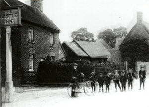
an Inn called “The Castle” just a bit further on you have a view through to the recreation ground which used to be ancient open field “Ridge & Furrow” until some “Crawley Savage” ploughed it up to make the level cricket field. “Ridge & Furrow” was an interesting term from which derived a “Furlong” or a Furrow long. This is 220 yards. The Cricket pitch is 22 yards or a “chain” long. A furlong multiplied by a chain is 4840 square yards which equals 1 acre.
Moving forward we walk through the “New Estate”, a development in the 1970’s which doubled the size of the village with some controversy at the time but which ensured the survival of the school, two pubs and a village shop. Many villages who rejected development have lost all these facilities.
We walk through “Kilpin Green” named after Michael Kilpin named in the Court Rolls and down Orchard Way
On the left is Hackett Place, the Hackett’s were a famous North Crawley Family the first of whom was Roger Hackett a Doctor of Divinity who was famous as a preacher who became Rector of North Crawley in 1590. His father was Lord Mayor of London. Roger was recorded as having bought several estates and putting them together he built the principal house in the whole parish later named Crawley Grange. Walking past the Anglian Water premises the footpath turns right past an old cottage which used to be occupied by “Bill Maslin”, Bill was a fireworks fanatic who made his own fireworks and gave the village free firework displays for over 50 years. His ancestors were “forty-niners” who joined the 1849 Gold rush to California with some success which enabled them to buy land in North Crawley.
Go over the stile and down the field towards Little Crawley, this path was originally a “Warded” footpath to carry the coffins from Little Crawley to St. Firmins Church for burial. On the left you can see “Moat Farm” the site of “Broughton Manor” once owned by the Lowndes family who owned land all over Buckinghamshire before enclosure of the open fields, which happened in North Crawley in 1773.
.
Over the next stile we enter a small field called “Bacchus” with a white bungalow on the left before crossing a bridge onto Little
Crawley Green which we cross and then bear left down the road towards the T junction where we turn right onto Chicheley Road, after few steps beyond the seat take the footpath on the right through a kissing gate.
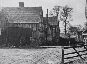
Little Crawley Farm on your right, now garaging a breakdown lorry business was also owned by the Lowndes family. The Lowndes family investments in land in Buckinghamshire originated from William Lowndes secretary to the Treasury and Auditor of the Exchequer who by 1722 had bought lands in Winslow, Granborough, Little Horwood, Chesham, Shenley Church End, Walton, Barton Hartshorn, North Crawley & Astwood. North Crawley produced his second highest rental income after Chesham.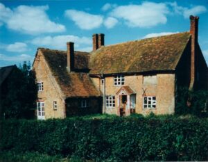
Continuing across this field through another kissing gate into one of the open fields before the 1773 enclosure awards called “Garden Field”. The path continues up by the side of the hedge through this field, veer left and right and continue until you come to a T junction, ignoring the path to the right to Brandon’s Wood take the left turn and continue straight ahead passing a turn to the right which goes to Chicheley.
We continue ahead walking along the side a large ditch called “Wolfeys Brook”. North Crawley had a number of brooks and before enclosure a strip either side where grass would grow lush was set aside as meadow for grazing this one was known as Wolfeys Mead which ends as you emerge onto the Little Crawley Road on a dangerous bend opposite a holding called “Griggs Piece”. At enclosure Thomas Griggs was awarded land but not in this part of the parish. He was 19 when he got married and had numerous children.
Carefully crossing the road and turning left walk back towards the village until reaching a footpath/bridleway on the right which we take going uphill, we are now in the open field named “Mill Hill Field”. A long way over to the right near the Newport Road there was a working Windmill at one time. Continue uphill until reaching the small gate on the left, go through this and turn right and continue along the side the hedge, continuing on through the gate follow the path down towards Brook End Farm yard which you pass through to the Crawley Road.
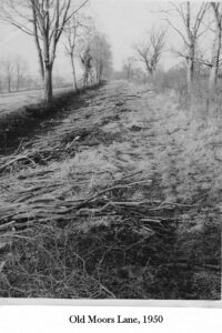
Cross the road and turn right and immediately left through a gate and continue up the hill which was once known as “Beggars Hill”, you are now on the bridleway which eventually comes out at Hurst End once known as “Moors Lane”
.
On the left is a field that in a recent local planning application was described as “Goodmans Field”. Actually in the Enclosure Award it was to be given to a widow Elizabeth Brandon. She then allocated it to her daughter who was married to John Goodman.
You are now in the largest “open field” before enclosure which was known as Moors Field and which covered much of the South of the village. In ancient times it was Moorland.
Continue forward and then take a left turn which goes uphill towards Folly Lane, reaching the kissing gate at Folly Lane cross the road and take the footpath opposite, aiming for the church, turn left through the field aiming for a telegraph pole, taking the footpath down to the brook, crossing the stile into the next field known as “The Rolles (otherwise Volles)” once owned by Richard Lowndes who was MP for Bucks for 45 years.
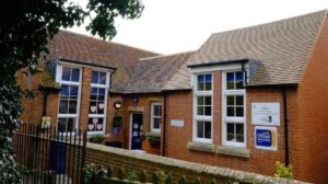
Carry straight on into church walk where on the left you will see the village school
.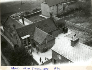
The Rector Thomas Lowndes with the blessing and consent of the Bishop of Lincoln donated the land, the approval for the school to be built took place on 28th May 1844 in the High Court. The National School of North Crawley was built jointly by the Reverend Thomas Lowndes and Thomas Alexander Boswell and received a subsidence of a Parliamentary Grant in 1845.
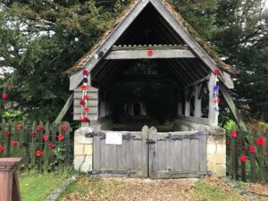
Continuing on we arrive back at our starting point on the waste ground by the church lych gate.