Iron Age settlement found in Whitehouse
Calverton Records Project asked Milton Keynes’ Senior Archaeologist, Nick Crank, to keep us informed of progress on the excavations which were being carried out ahead of the development in the SE corner of the original Calverton parish. This had been designated Western Expansion Area 10 and now forms the new parish of Whitehouse. He kindly arranged a site visit to view the work being done by the Council’s archaeological contractors – North Pennines Archaeology.
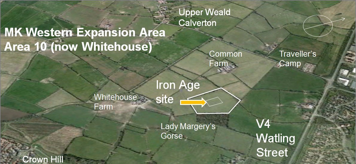
A group of interested villagers from Calverton Records Project assembled near the old Common Farm buildings off Calverton Lane to meet Nick Crank and representatives from the archaeological contractors. We were also joined by local archaeological experts Paul and Charmian Woodfield and also members of Wolverton and District Archaeological and Historical Society (WADAHS). When we visited the site the remains of two Iron Age roundhouses had been revealed representing a well-preserved small mid to late Iron Age settlement.
The contractors had surface stripped back a large area to a depth of about 0.3m (1ft) revealing just hints of changes in soil colouring which the archaeological team had highlighted using fluorescent spray paint. The areas within the painted outlines had been carefully dug out in a semi-circular fashion to allow a vertical cross section of the hole to be seen showing the stratification (i.e. layering of deposits in the previous hole or ditch).
Typically these were excavated to show cross sections through the drip gully, a sort of shallow circular ditch originally dug around the outside of each house to catch the rain drips falling from the lower edge of the thatch and conduct the water away from the house walls.

The Iron Age Roundhouses
The drip gulley evidence pointed to circular houses some 10m (32ft) in diameter. As there was no evidence of any circular pattern of post-holes associated with the gully, it has been suggested that the construction of this kind of dwelling was based on a low peripheral wall made from piled turves, or compacted earth, straw and dung (called cob) or possibly by woven wooden hurdles plastered with a similar cob type mix (wattle and daub). Rising up from the wall would have been a conical roof structure fabricated from long wooden poles bound together with strips of bark or vegetable fibre (flax or sisal) and then thatched with straw or reed. All of these natural materials rot away and leave little archaeological evidence behind. However the drip gully tends to fill up with silt which shows up as a darker coloured band in the ground around the periphery of the house.
One house plan was built approximately over the remains of a previous similar dwelling showing that the site was occupied for some considerable period with the occupants rebuilding in the same place when the earlier house became untenable.


Interestingly in two of the houses the remains of open hearths (used for cooking, light and heat) could be seen in the form of burnt areas of ground and stones. It is unusual to find these sorts of remains – they are more often destroyed by ploughing (referred to as being ploughed-out) during subsequent periods.
One of the most exciting things we saw was a substantially complete cooking pot still in the ground and in the process of being revealed before lifting for preservation.

Since our visit to the site a further separate round house has been identified which indicates that this was more of a small settlement rather than just one isolated unit. This type of extended settlement is somewhat unusual on our heavy clay soil and indicates the wider spread of Iron-Age farming even to areas with less than ideal ground conditions.

Subsequently two large pits with steep sloping sides were also identified and excavated down to the water table where log ladders were found preserved in the wet conditions. These ladders were made from tree trunks with notches cut into them to form a series of steps and would have allowed access to the bottom of the pit by avoiding the slippery sides. People may have gone down to draw water or possibly to collect clay for use in building or pot making. These substantial finds are said to be of national importance and have been removed to laboratories in York for preservation. The ladders have been provisionally dated to the early Iron Age but unfortunately more accurate dendrological (tree ring) dating has not revealed a sufficient number of rings to provide an identifiable sequence which could have led to a firmer date.
The archaeologists from North Pennines Archaeology are due to produce an interim report which should feature their various interpretations of the site together with plans and drawings showing the positions of the houses, hearths and doorways of the settlement.
Feedback form