
To read the related historical information, select one of the highlighted locations on the interactive map.
The historical data is taken from A C Chibnall’s book Sherington – Fiefs and Fields of a Buckinghamshire Village.
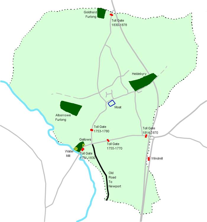
Goldhord Furlong
In 1318, this field was called Goldhord (from the Old English hord, treasure), which suggests that buried treasure was found here. This might have been hidden by people fleeing from an attack on a nearby town. It is known that the Danes used Northampton as a base for raids into the surrounding countryside, and some of these were along the banks of the River Ouse. Later the name became Goldsworth.
Heldebyry
In 1313 this field was called Heldebyry (from the Old English byrig, which is the dative of burg). This name implies that there were ruins of an earlier Anglo-Saxon fortified manor house. This may have been the one belonging to Edwin (the son of Borred, who was a thegn of King Stephen) who is recorded in the Domesday Book as holding 6 hides prior to the Norman Conquest.
Alborrowe Furlong
In the 16th Century, this field was called Alborrowe Furlong. This name is derived from the Old English ealdeburg, old fort. This would have been an appropriate location for local defences as it lies on the higher ground just south of Water Lane, overlooking the river valley. More recently, the name has been Elbrough.
Moat
The principal Sherington manor immediately after the Norman Conquest was originally located here, protected by the moat. It is thought to have been damaged or destroyed during the anarchy of King Stephen’s reign in 1135-1153. The principal manor (owned by the de Carun family) was then moved to a new site just north of the church (where Church Farm now stands). The original manor house, having been repaired or re-built, became a subsidiary manor and subsequent owners included the de Cave family. This manor house was finally demolished by Dryden Smith around 1770 and a new house was built just outside the moat. The area inside the moat became the garden. This house and garden still survives today as ‘The Manor House’.
Windmill
The windmill was situated just over the parish boundary in Chicheley. It was constructed c.1275 by Tickford Priory. The neighbouring field in Sherington was known as Windmill Field. The windmill was closed and demolished c.1755 when the Turnpike Trust for the Bedford/Newport road was set up. The Trust was empowered to close side roads that could be used as a means of escaping payment and the resultant closure of Blackbird Lane (previously called Monchlade) in Chicheley prevented access to the mill. Around 1800, a new windmill was built near the road junction east of Sherington Bridge (where Charlesberry Kennels are today).
Water Mill
The water mill is recorded in the Domesday Book. It was a significant mill, as it was rated at 26 shillings, more than any other mill in Buckinghamshire. It had 3 paddle wheels. In 1189 the Cockfield family acquired a half share. At some other time about then, the other half share was acquired by William son of Alexander. In 1241, Robert de Cockfield and William son of Alexander (nephew of the previous William son of Alexander) strengthened the mill pond. In 1261, Robert de Cockfield attempted to get William’s various heirs (one of whom was John de Cave of the Manor House) to contribute to repairs. A few years later, competition from the new windmill caused it to close. By about 1284, William’s grandson, Richard de Shirford, is claiming one sixth of the mill site.
The precise location of the mill and the millpond is not known, changes in the riverbed over the years, due to silting etc, serving to confuse the issue. However, in 1325 the field beside the river here was called Wateswollen (Old English swelgend, gulf, whirlpool) which would have referred to the whirlpool created down river by the mill’s paddles. In 1575 this furlong was called Water Swallows.
Gallows
The field immediately north of Sherington Bridge was called Wartrou Furlong in medieval times. Wartrou comes from the Old English wearg, felon, and treow, tree. This implies that in Anglo-Saxon or Early Norman times it lay alongside the local gallows. These were often located in prominent locations such as near bridges or road junctions. A thorn tree may have been used for this purpose, as they were common in the area. By the 1600’s the field had become known as Bridge Leys Furlong, although it was still referred to as Water Thorn furlong (a corruption of the earlier name) by some.
Old Road to Newport
Before Sherington Bridge was built, the original road from Sherington to Newport was on the east side of the river. It passed through the westernmost end of Chicheley and went near to Tickford Priory, reaching the London road in Newport near the bridge over the Ousel. The Old Road lay on higher ground and, although it followed a longer and more indirect route, it would have remained open when the ford on the short cut across the river became impassable during floods. It is known there was a bridge in the 13th Century, but this was probably just a simple wooden structure. In 1491 Richard Maryot gave money in his will for the construction of a new stone bridge. After this, the old road was no longer needed and subsequently fell into disuse.