Home » People » Land Ownership » 1910 Land Valuation Survey – Introduction » 1910 Land Valuation Survey – Mapping Introduction »

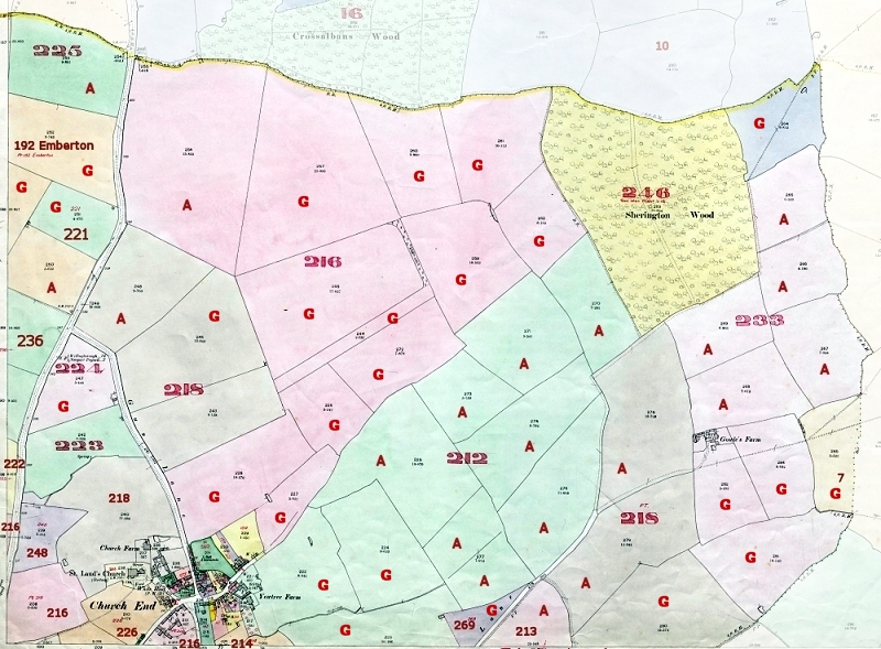
Note: The map shown above contains a combination of information from the two sets of survey maps. The fields marked ‘A’ were recorded as being ‘Arable’, whilst those marked ‘G’ were recorded as being ‘Grass’.
The 1910 Land Valuation Assessment Numbers are those shown on the map in RED
| No. of Assess -ment |
Christian Names and Surnames of Occupiers |
Christian Names and Surnames of Owners, with their Residences |
Description of Property – If an Inn, etc, the name or sign by which known |
Street, Place, Name and Precise Situation of Property |
||
| 212 | Burgess | Thomas | T Barton Exor | Newport Pagnell | Farm House, Buildings, Land | Church End, Yew Tree Farm |
| 213 | Burgess | Thomas | Farm Land Arable | Perry Lane, New Pasture | ||
| 214 | Burgess | Thomas | H Rogers | Farm Land | Bodington Leys | |
| 216 | Weeks | William | F A Konig | Farm House, Buildings, Land & 3 cottages |
Church End Farm | |
| 218 | Field | F J | Rev John Chester | Chicheley | Farm House, Buildings, Land | Church Farm |
| 221 | Austin | Abel | H Rogers | Farm Land | Olney Road | |
| 222 | Oldham | Owen | H Rogers | Farm Land | Olney Road | |
| 223 | Hickson | W J | Mrs Whitman | Northampton | Farm Land & Building | Olney Road |
| 224 | Hickson | W J | Mrs Thompson Exor | Northampton | Farm Land | Olney Road |
| 225 | Mynard | George | Mrs Longland | Olney | Farm Land Arable | Sherington Field |
| 226 | Field | John | John Field | Farm House, Land | Church End | |
| 233 | Simco | Henry | Payne Exrs | Farm House, Buildings, Land | Gowels Farm | |
| 236 | Harding | Jane | Harey Harris | Farm House, Buildings, Land | High Street, Part of Village Farm | |
| 246 | Konig | F. A. | F A. Konig | Woods & Coldis (?) | Church End Farm Sherington | |
| 248 | Fleet | George | Aspray | 37 Kings Wood Rd | Farm Land | Olney Road |
| 269 | Burgess | J. T. | Bowyer Alfred | Land | Perry Lane, Sherington | |
Note: The information in the above table is a subset of the data in the “Domesday Book” and does not include the information from the Field Books.
It is recommended that you review the other 1910 Land Survey pages to obtain a more complete picture.
