Home » People » Land Ownership » 1910 Land Valuation Survey – Introduction » 1910 Land Valuation Survey – Mapping Introduction »

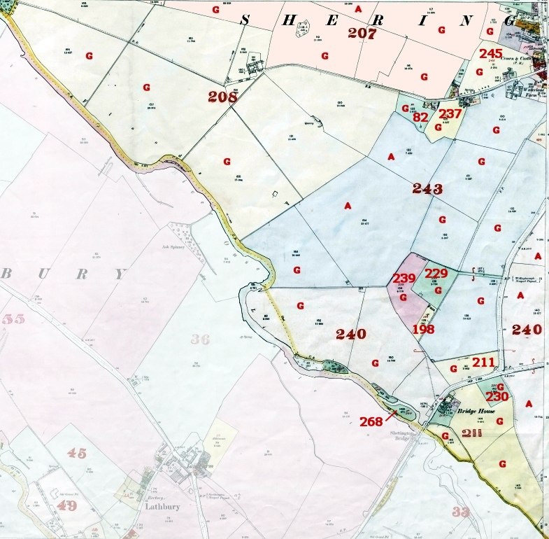
Note: The map shown above contains a combination of information from the two sets of survey maps. The fields marked ‘A’ were recorded as being ‘Arable’, whilst those marked ‘G’ were recorded as being ‘Grass’.
The 1910 Land Valuation Assessment Numbers are those shown on the map in RED
| No. of Assess -ment |
Christian Names and Surnames of Occupiers |
Christian Names and Surnames of Owners, with their Residences |
Description of Property – If an Inn, etc, the name or sign by which known |
Street, Place, Name and Precise Situation of Property |
||
| 82 | Jayd | Sarah | E J West | Newport Pagnell | Cottage | Water Lane |
| 198 | Moar | J E | J E Moar | Sherington | House & Buildings, Garden Land | Mill Ho |
| 207 | Gardner | Ellen | Mrs Wilson | London | Farm House, Building, Land | High Street |
| 208 | Adkins | John Trus | John Adkins Trus | Lathbury | Farm Cottage, Buildings, Land | Water Lane |
| 211 | Jefferson | & Son | Mrs Russell | Sherington Bridge | Farm Buildings, Land | The Lodge, Sherington Bridge |
| 229 | West | Henry | Sherington Parish Council | Farm Land | Stonepit Close | |
| 230 | Fleet | George G | Sherington Church Trus | Farm Land | Waypost Field | |
| 237 | Rose | Henry G | H G Rose | Sherington | Farm Land | Water Lane |
| 239 | Pettit | Richard | R Pettet | Newport Pagnell | Farm Land | Stonepit Close |
| 240 | Jefferson | & Son | Mercers Company | London | Farm House, Buildings, Land | Mercers Farm, Croft End |
| 243 | Graves | J W | Mrs Wilson | London | Farm House, Buildings, Land | Water Lane |
| 245 | Rose | G. H. | Mrs Wilson | London | Farm Land | Umneys Close |
| 268 | Jefferson | Edward J. | Konig F. A. | Osiers | Sherington Bridge | |
Note: The information in the above table is a subset of the data in the “Domesday Book” and does not include the information from the Field Books.
It is recommended that you review the other 1910 Land Survey pages to obtain a more complete picture.
