
Olney Field Names
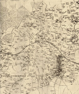 In the 1970s Mrs Sylvia Colson, a local farmer’s wife, undertook the considerable task of collecting and presenting the names of the fields around the town of Olney. She chose the 1958 Ordnance Survey Map (six inches to the mile) on which to display the field names; quite a considerable task in itself. We have uploaded the map in a format that allows the content can be examined in detail. We are of course indebted to Sylvia for allowing us to reproduce the map on this site.
It will be observed that the street names of many of the more recent developments in the town are derived from these field names.
Click this link to see the detailed format.
Growth of Olney over the past 130 years
Further to Sylvia’s work, the following link provides a side-by-side comparison of the current territory covered by Olney with that in late Victorian times (c. 1885). This work was undertaken by the National Library of Scotland, to whom we are indebted, because the display provides a snapshot of the growth of Olney over the past 130 years.