
Danesborough Hill Fort, Aspley Heath
The remains of Danesborough hill fort can be found in the woods to the west of Aspley Heath.
Not much can be seen on the ground today, as there are only vague ditches and mounds visible. Once it was a well-defended point in the hills overlooking the relative plain that the Romans built Watling Street across, and close by to their settlement at Magiovinium. Markham, in his History of Milton Keynes and District, 1973, suggests that it may have been anti-Roman tribesmen who built the fort. The boundary of the land that the Danes controlled under ‘Danelaw’ is not far away, near Bedford, but this was not until the late 800’s, so why the name ‘Danesborough’ was given to the site, by whom, and when, is lost in the mists of time.
Locally, the site would seem to have given its name to ‘Daneswood’, a convalescent home on Aspley Heath, (which started out as the Jewish Home for Consumptives) and the ‘Danesborough Chorus’, a much respected choral group who have performed all over the country.
There was an archaeological investigation of the site in 1924, reported as “Excavations at Danesborough Camp, by James Berry”, in the “Records of Bucks” Vol 11 – No. 7, in 1926, some of which is reproduced below, with the kind permission of the Buckinghamshire Archaeological Society.
Excavations at Danesborough Camp, by James Berry
The small excavations described in this paper were made on May 28, 29, and 30, 1924, by Mr. W. Bradbrooke, Col. James Wyness, and myself. A fourth day, May 31, was occupied in filling in and restoring the external surface to its previous appearance. The site was visited during the progress of the work by Mr. E. Hollis (Curator, Aylesbury Museum), Mr. G. Eland (Editor, “Bucks Records”), Mr. W. Barnes (Hon. Sec., Bucks A. & A. Society). Rev. F. W. Bennitt, Dr. G. Scott Williamson, Mr. S. A. Sewell, Mrs. Bradbrooke, and Lady Berry, all of whom rendered assistance. The actual digging was done by John Jackson, of Bletchley, John Chinn, of Woburn Sands, Lawrence Williamson, of Fenny Stratford, and Thomas North, Thomas Judd, and John Williamson, of Bow Brickhill, who worked with intelligence and good will.
The object was to ascertain, if possible,
1. Whether the popular attribution of the “camp” to the Danes is correct, or not.
2. Whether the causeway across the encircling ditch, opposite the supposed original entrance on the S.W. side, formed part of the original structure of the earthwork, as seemed probable, or if it were merely mediaeval, or later, filling in of the ditch.
Both these problems were solved.
1 The pottery unearthed was partly of Early Iron Age, and partly Romano-British. Nothing was found that could be definitely dated later than the second century A.D. and most of it was of about 1st Cent. B.C. to 1st Cent. A.D.
2. The causeway was proved to be undoubtedly original.
We desire to express our cordial thanks to Mr. Reginald Smith, F.S.A., of the British Museum, and Dr. Cyril Fox, F.S.A., late of Cambridge, now of the National Museum of Wales, for kind help in the dating of this pottery. Mr. Smith was also good to visit the site with us before the excavations were begun.
Description of the site The Earthwork is on the estate of the Duke of Bedford, who kindly permitted the exploration, and has also been so good as to present all the objects found to the Bucks A. & A. Society’s Museum, where they now are. Danesborough Camp is the designation of this large earthwork situated in Wavendon Wood close to the Beds border of this county.
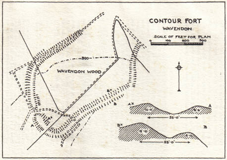
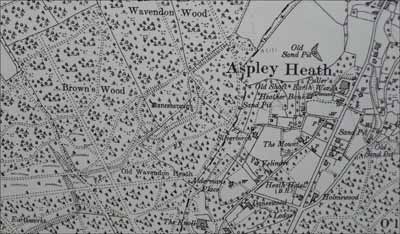
In the North Bucks volume (p. 313) of the Report by the Historical Monuments Commission, it is described as of the “contour fort” type and a plan given, of which Fig. 1 is a reproduction. The reduced plan on the 6 inch Ord. Survey Map (sheet XV. S.E.) also shows approximately the shape of the camp, and the supposed situation of the entrance. The shape is roughly oval or rectangular with rounded corners, and encloses about 8½ acres. It is 1,100 yards E.N.E, of Bow Brickhill Church, about the same distance S.W. of Woburn Sands village, and nearly two miles S.S.E. of Wavendon. It is rather more than two miles from and more than 270 feet higher than the point at which Watling Street crosses the site of Roman Magiovinium or Magiovintum, a little south of Fenny Stratford. Placed upon a projecting spur of the Lower Greensand at a height of 500 feet it commands (in the absence of surrounding trees) an extensive view northwards towards Newport Pagnell and Olney, and, north-eastwards, towards Bedford, 12 miles distant.
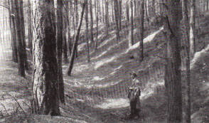
It is protected by a very steep slope on the S.E. side, and by less steep ground on the N.W. and N.E. On the S.W. side there is no protecting slope. At the northern angle the sandy plateau on which the camp is placed becomes a ridge which descends towards Woburn Sands. The rampart and ditch which surround the camp are particularly well marked on the S.E. (Fig. 2) and S.W. sides, but on the other sides have been sadly denuded by mediaeval or modern tracks.
Entrances At the N.E. corner is a wide gap which may possibly mark the site of an original entrance, although in an unusual situation. Leading up to this along the above-mentioned ridge is a sunken way, now a footpath from Woburn Sands. Inside the camp this hollow way extends nearly to the south corner, where, much altered in appearance, it passes out through the vallum a few yards to the north of this corner. There is nothing in the appearance or position of this latter gap to suggest that it could ever have formed any part of the original design. In the S.E. vallum is another narrow gap which obviously is not original. There is no corresponding gap in the counterscarp bank, and the slight filling up of the ditch is evidently due to the material from the vallum having been thrown into it. There is no evidence of any ancient road having led up to this portion of the camp. It was not thought necessary to attempt any excavation here.
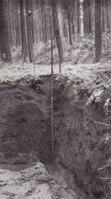
Western entrance Near the middle of the S.W. side, where the ditch is exceedingly well defined, it is crossed by a narrow causeway leading to a gap in the vallum, here much denuded, especially on the north side. This gap, now occupied by a modern footpath, appeared to be an original entrance. It was on this causeway and in the ditch on either side of it that the excavations were made (Fig. 7).
Excavations The camp being in the middle of a thickly planted pine wood, the trees of which we were forbidden to disturb, made the choice of ground for excavation very difficult and limited.
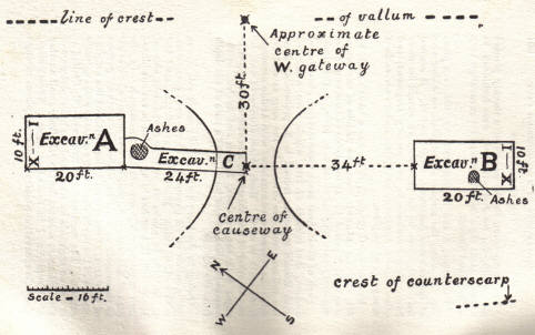
Two areas, A and B, each 20ft. by 10ft. (see plan, Fig. 7), along the middle of the ditch on either side of the entrance causeway, were selected. It seemed that here, close to the entrance, we should be more likely than elsewhere to find pottery fragments and other objects rejected or lost by the makers and earliest occupants of the place.
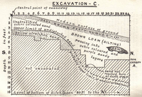
Excavation C (Figs. 7, 8, 9) was a trench 24ft. by 4ft. running outwards from the middle of the causeway until it joined A. It was made to ascertain if the causeway were original or made by filling in the ditch.
Each of these three areas were divided, chess-board fashion, into squares of 1ft., which were numbered with Roman numerals from I to X, proceeding from the vallum across the ditch. In the long axis of the ditch the squares were numbered with Arabic numerals from south to north. Each object discovered was, by one or other of the observers, immediately wrapped in paper with the numbers, Roman and Arabic, of the square in which it was found, and a note of the depth from the surface.
Owing to the loose nature of the sandy soil it was not possible in all places to make a deep excavation with vertical sides. Blocks of unexcavated sand had to be left in places at each end and one side of Excavation B, trenches being carried in various places into unmistakeably undisturbed greensand. In the case of Excavation A, time did not permit of exposing as thoroughly as could be wished the southern portion of this area. Consequently, very little of the original surface of the north slope of the causeway was actually exposed. The narrowness of Excavation C, limited as it was on each side by trees, and the incompleteness of Excavation A, account for the relatively small number of objects found in these two areas. Nevertheless, since the excavation penetrated in many places through the silting into undisturbed soil, we were able to obtain a fairly good idea of the shape of the slope on either side of the causeway (Fig. 9) and of the adjacent ditch. The bottom of the ditch in A and B was found to be U shaped. This must not be regarded, however, as indicating that the bottom of the remoter parts was not of the usual V shape, because the presence of the sloping sides of the causeway would necessarily in such soil transform a V into a U. It is obviously far more difficult to determine the exact outline of a ditch cut in sand than in chalk, in which so many Bronze and Iron Age camps have been excavated in this country. In the second case the contrast between the white chalk in which the ditch is cut and the material with which it is subsequently filled, is much greater than in the first case.
The Causeway The causeway some 60ft. long is nearly level, there being an ascent of about one foot from its centre to the entrance in the vallum (Figs. 7, 8). The ditch close to the causeway on the south side is slightly wider than elsewhere, since the counterscarp bank, here about 3-4 feet high, bends a little outwards away from the camp., On the opposite (northern) side, the ditch near the causeway appears now to be narrower. This apparent narrowing is due, however, to the construction of a modern track. In making this the material of the bank has evidently been removed and thrown into the ditch. If the curve of the counterscarp bank, at some little distance to the north, where it has not been disturbed, be prolonged, it will be found to fall approximately into line with that of the south side. Doubtless, in its original condition, it also bent slightly away from the vallum as it approached the entrance to the camp.
Excavation C (Figs. 8, 9) quickly proved that the causeway formed part of the original plan of the camp, no ditch having been dug here. Beneath a few inches of humus lay two feet of dark, muddy, unstratified ochre-coloured sand, possibly natural, but apparently a good deal disturbed. Beneath this again, at a depth of only three feet, was unmistakable natural Greensand, which had never been disturbed. Of a yellow colour, it was stratified and marked with darker bands of characteristic, ferruginous staining. On tracing the upper surface of this layer of undisturbed greensand outwards towards the ditch, it was found to bend down, somewhat abruptly, at a distance of about 10ft. from the centre of the causeway, which had, therefore, originally a breadth of some 20ft.Although the middle part of this slope down to the ditch was not actually exposed, yet further outwards (in excavation A) the same sandy layer was reached in several plaices, so that the approximate position of the original slope from causeway to ditch was fairly accurately ascertained. Owing to the partial filling up of the ditch on its west side our excavation A did not lie exactly over the centre of the original ditch, but was mostly on the vallum side of it.
The nature of the material excavated at A and B consisted mainly of sandy and muddy layers of silting, varying in colour from yellow or ochre-colour to dark reddish-brown or purple, all beneath a superficial layer (6-9 inches) of peaty humus in which pine needles were a prominent feature.
The true bottom of the ditch was reached at 9ft. in A and 8ft. in B.
Many flint chips, foreign of course to the soil in which they were found, were discovered in, all three excavations, but chiefly in the deeper layers of A and B. They presented all degrees of patination. One large flake which I saw removed from the very bottom of the B ditch had sharp, razor-like edges, and no patination at all on its freshly fractured surfaces. Only two flints showed definite evidence of human workmanship. One was a very beautiful triangular pigmy (9/16 x 5/32 x 3/32 inch) with well-marked secondary chipping along the butt edge. It was found in A at a depth of 1 foot, and 13 feet from the centre of the causeway. The other flake (1 5/8 inch long) showed no secondary chipping.
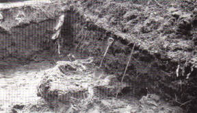
During the progress of the excavations in the sandy soil, numerous nodular masses and flat slabs of iron-sandstone were found at the deeper levels in all three excavations. Layers and nodules of this material occur naturally in greensand, and would be found in material thrown up from it.
In two places in excavations B and C, a number of these stones were found arranged to form very rough hearths, on each of which was a lenticular layer of wood ashes about 9 inches thick at the centre and about 3 feet in diameter. The exact shape and position of these masses of ash are shown in Fig. 10. At first it was thought that they might mark the sites of small potters’ kilns or possibly of a primitive smelting furnace. The complete absence of any wasters of pottery or of scoriae or slag, and the rudeness of the arrangement of the stones, at once negatived any such idea.
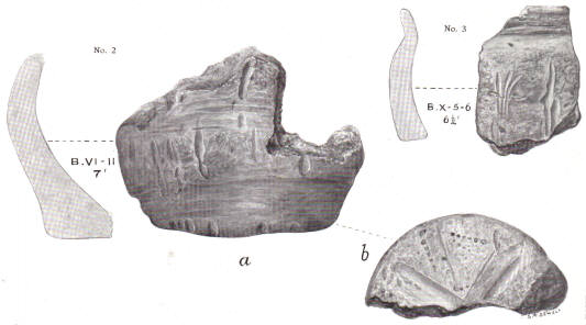
By far the most important objects found were numerous fragments of pottery. Considering the very limited extent of the excavations, we were fortunate in finding as much as we did, and still more in that most of it could be dated at least approximately, within the comparatively narrow limits of two or three centuries.
Pottery [A full transcript of all the finds is not reproduced here. Please see the original publication for these details.]
Conclusions It is the duty of a local archaeological society to record facts, with as much detail as possible, and not to wander off too much into the realm of theory, in which it is easy to go astray. Facts duly and carefully recorded may be of considerable value to experts whose wider knowledge may enable them to draw conclusions and to generalise in a manner which it is not always wise for amateurs to attempt.
The classification and dating of Early Iron Age pottery is admittedly very difficult. Speaking generally, more is known at present about the identification of Bronze Age pottery than of Early Iron Age pottery. It is often hard to say definitely whether a particular piece of pottery should be attributed to the Early Iron Age or to the subsequent Romano-British; period. No doubt there was much overlapping of the two periods. In different parts of the country, or even in the same part, both kinds of pottery were being simultaneously manufactured side by side for a considerable time, until the superior culture of the invaders gradually replaced that of the natives. It must not be assumed that upon the advent of the Romans to our country, the British potters immediately dropped their tools and methods and adopted those of their conquerors. The process of conversion must often have been a gradual one.
Although negative evidence is not of any great value in the case of excavations of such limited extent, yet no Bronze Age pottery was forthcoming, nor any that could reasonably be dated later than about the second century A.D. No glazed pottery, or coins, or any objects of metal or glass were found.
The pottery that was found made it clear that the ditch was in existence at least many centuries before the period of the Danish invasions. It could not have been made by these people. Whether they, at any time, occupied the already existing enclosure is .another matter, upon which the excavations afford no evidence either for or against.
Similarly, the few flint flakes found, of which only two show definite evidence of human workmanship, afford no help in the dating of the camp. The Neolithic people, who presumably worked these flints, may have wandered about upon, or even occupied, the site long before the camp was made, and dropped these flints upon the ground.
The finding of so many fragments of pottery of Early Iron or Romano-British Age, so near the bottom of the ditch, and the complete absence of any pottery of still earlier date, make it unlikely that the ditch was made, at most, more than a very few centuries before the advent of the Romans to this country. On the other hand, it must be remembered that only an extremely small portion of the actual bottom of the ditch has been uncovered. Subsequent exploration will doubtless throw fresh light upon the subject, and may serve to confirm or modify the conclusions at which we have arrived. The presence of the two piles of ashes in excavation B and C tell us but little. Situated in each case 3-4ft. below the present surface of the ground and approximately on the same level as the later fragments of pottery, they have no necessary connection with the inhabitants of the camp. They may well have come from fires lighted by some casual wanderers who may have sought a temporary shelter in the ditch perhaps after the camp had been abandoned by its original makers and inhabitants. Within the necessary narrow limits of the present exploration it is clear that the work was abundantly justified by the effectual answers it gave to the two main questions raised. Meanwhile the results encourage one to hope that it may be found possible, at some future time, to make a further examination on similar lines, with a view to answering some of the many other questions which arise in connection with this important and interesting earthwork.
Article reproduced with the kind permission of the Buckinghamshire Archaeological Society.
Page last updated Jan. 2019.