
Woburn Sands Heritage Trail
This Heritage Trail was originally produced by Woburn Sands Town Council and myself in 2007 to celebrate the Centenary of the Parish of Woburn Sands, as the former “Hogsty End” of Wavendon Parish became a civic parish in its own right in 1907, holding its first council meeting in April that year. The Ecclesiastical Parish had been formed earlier in 1867 and includes Aspley Heath where the Parish Church of St. Michael’s stands, serving both Aspley Heath and Woburn Sands.
When Woburn Sands first became a separate parish, it was part of the Newport Pagnell Rural District Council in the County of Buckinghamshire. It remained a rural parish until 1974, when the facilities of the village far surpassed those in most villages, notably because of the number of shops and businesses, and the parish applied for Town Council status, which was granted and we are now the Town of Woburn Sands.
Due to continued development and changes since 2007, this Trail has now been updated and reissued in 2024 for the 50th anniversary of Woburn Sands officially becoming a Town.
We hope you will enjoy this walk around Woburn Sands and part of Aspley Heath. If you are new to the district, it will provide some of the history of our town and the stories connected to it. If you are local, we hope you will find something of interest about your surroundings.
As well as the many cafes and restaurants on the High Street, the trail takes in five pubs, so if you time the walk correctly, you can call in for refreshments! There are litterbins situated around the town for your refuse. Please clean up after your dog if you bring one. One part of the trail has a small number of steps, but an alternative route is given. Although one of the footpath passages is quite narrow, there are no barriers to deal with.
The numbers referred to on the map below are listed against the points of interest on the trail.
The Trail
If arriving by car, you will find the entrance to the Town Carpark in Russell Street, which is a turning off the High Street, at the northern end of our parade of shops. Turn in where you see the P sign and bear right to “SHOPPERS PARKING”. (Satnav: MK17 8NU) The carpark is free and has EV charging points. Please remember to keep your valuables out of sight and lock your car.
In the carpark, you will see a finger signpost pointing “TO THE SHOPS”. Follow the sign and leave the carpark on foot up pedestrianised Club Lane, a walkway with some pretty period cottages which leads up to the High Street. As you enter the High Street, cross at the zebra crossing in front of you, to look at:
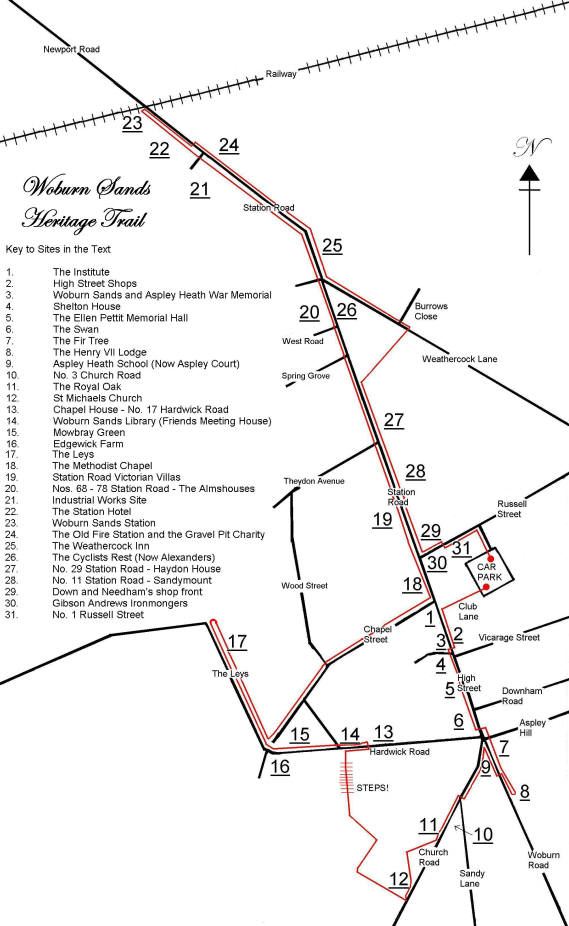
1. The Institute. The Rev. Hay Erskine bought a vacant plot of land beside his Vicarage in 1870 and gave it to the parish for the building of a public hall. It was founded under the “Literary & Scientific Institutions Act” which gave it the name “Institute” and was controlled by trustees. The original subscribers list survives and shows that the Duke of Bedford gave £100 and almost every other local citizen contributed. It was well-used, with concerts, dances and events, as well as a library of books. The fine pitch-pine floor gave one of the best dancing surfaces in the district. It is now the home of Woburn Sands Library, assisted by many local volunteers and has a good collection of Woburn Sands history books, if you want to know more after your tour.
Walk along the pavement towards the War Memorial. Look across the road at the shop fronts:
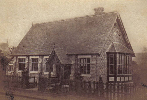
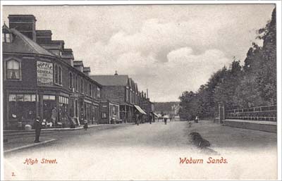
2. The Shops. Most of the shop frontages were built out from existing houses and cottages that once stood on this road. At one time, the west side of the road where you are stood, was a large farm estate, so development was limited to the east side of the road. Some still have period features – at no.31, now Grapevine wine-bar, there is a Fleur-de-Lys feathers at the left-hand end of the shop façade, a symbol used by the Prince of Wales. It is said that a young Prince of Wales shopped there for his sweets when it was Bathurst’s Chemists while staying near Woburn Sands with friends in the 1920s, so the shopkeeper felt he had earned a self-proclaimed Royal connection! The ironmongers, Gibson Andrews, located at the north end at the corner of the High Street and Russell Street, is one of the few shops with an original façade and tiling. The High Street brought in trade from all the surrounding villages.
There used to be butchers, a fishmonger and game dealer, bakers, banks, electrical appliances, haberdashery, school outfitter, shoe shop, greengrocer, wool shop, sweet shop, antique shop, gift shop, hat hire and many more, long since gone. The shops still provide for the daily needs of residents, but has diversified into other functions as well. The centre of Woburn Sands attracts in visitors and shoppers from the wider area as it is only one of the few traditional High Streets in Milton Keynes. It has changed with the times: in 2021, to the amusement of both children and adults alike, the little Starship robots were introduced as a new shopping experience. Who knows what will happen over the next 50 years!
Now you reach Woburn Sands War Memorial:
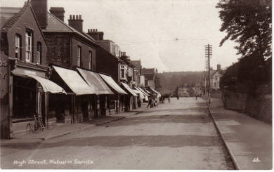
3. The War Memorial. Our War Memorial holds the names of 43 World War I and 8 World War II casualties from this area. The Memorial used to stand in the Square, in the main road junction at the top of the town, but weight of traffic and a series of accidents caused it to be moved to this site in 1972 by a forklift truck. The three Burt’s listed are all brothers.
Walk a little way down the road by the side of the Memorial to view the frontage of:
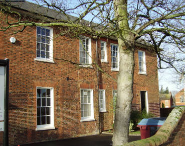
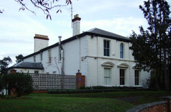
4. Shelton House. This imposing building was probably built by the Denison family, who were lords of the Manor of Wavendon and lived there for several generations. The Denison’s funded an early school in buildings connected with The Swan and William Denison was one of the first Churchwardens when St. Michael’s was built in 1868. He gave this building to be the Vicarage, which it remained until about 1968. The main entrance is here at the rear of the house, which once had extensive views. William died during a service at St. Michael’s in 1890.
Back at the High Street, turn right and next to Shelton House stands:
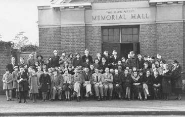
5. The Memorial Hall. A draper, Alfred Pettit, retired to Aspley Heath before the First World War. He was a Churchwarden from 1915-1923 and was a director of the Aspley Guise & Woburn Sands Golf Club when it was formed in 1913. His house, “Croylands”, was where the first Directors’ Meetings were held. When his wife died in 1927, he funded the building of this hall in the grounds of the then Vicarage in her memory. Alfred died in 1934.
Next you come to:
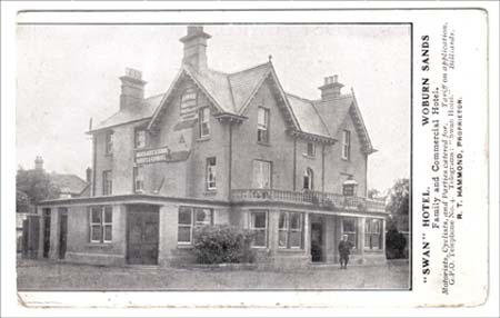
6. The Swan. Originally called The Coach and Horses, this inn can be found in the Bucks Register of Ale House which starts in 1753. It became The Swan in 1809. The road through Woburn Sands was turnpiked and used as a major coach route northward, which would have needed inns to change horses and accommodate travellers. The inn was once part of the Mr Higgins’ farm, as was most of Woburn Sands. Some of the boundary walls and beams in the cellar are original parts of the old building, but it was rebuilt c.1840 and extensively remodelled several times since. There used to be a bowling green beside the pub, now used as the car park.
The War Memorial you saw earlier used to stand approximately where the first mini roundabout is. Re-cross the High Street by the island in the road in front of The Swan. Walk further on, across the turning into Aspley Hill and you have crossed into Bedfordshire. You are now at:
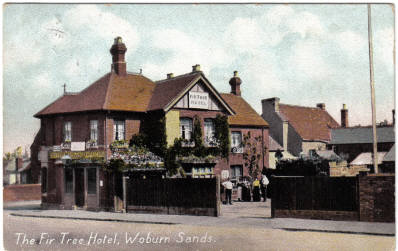
7. The Fir Tree. A landlord brought the name with him from another inn, which was further south on the road to Woburn, in about 1850. Three generations of the Lee family, all called Francis, were landlords of these pubs of the same name, but on two different sites – very confusing! The building you see today was erected in 1889. The original coach block has been converted to hotel rooms and the stabling at the rear of the car park is now storage & offices.
Continue past the pub in the same direction. In the little cottages just after the pub, a gruesome murder occurred in 1899, when a lodger killed his landlady and committed suicide with a cut throat razor. Just beyond this, a short distance straight on up Woburn Road at the edge of the Duke of Bedford’s woods, stands:
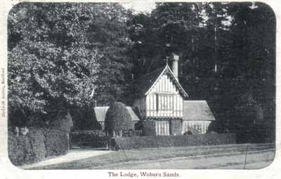
8. Henry VII Lodge. This lodge was erected by the Duke of Bedford in 1811. It was built as a model of what gothic lodges would have looked like in the 13th-14th centuries. Inspiration was taken from a collection of period buildings from far and wide and the original gardens to the house had an intricate maze which Queen Victoria visited in the 1841 whilst staying at Woburn Abbey. Mostly hidden now by high hedges, you can find it by looking for the ornate chimney pots. The Lodge features on many pieces of commemorative china and dozens of postcard views have been taken of it.
Turn around to face Woburn Sands again, and trace your steps back a little. Once back at The Fir Tree, cross the road using the traffic island. Aspley Court, in front of you, is a warden-assisted flats development, but once here stood:
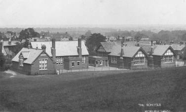
9. Aspley Heath School. The large Victorian school, which was in Bedfordshire, had several additions over the years. It was built in 1868 and opened a week before the Church, both of which were funded by The Duke of Bedford. An 1890 directory reported space for 240 children with average actual attendance of 220. It survived until the early 1980s, when a new modern school was built at the northern end of the town, but still in Central Bedfordshire: Swallowfield School is attended by many of the children of Woburn Sands.
When you arrive back at the main junction, follow the footpath around the sharp corner to your left, and enter Church Road and Aspley Heath. There is a plaque on the garden land on your left hand side, beside the 1977 Jubilee bench, giving some history of Aspley Heath. Continue on this footpath until Sandy Lane appears in front of you. You need to cross the road to the pavement on the right and continue to climb into Aspley Heath via Church Road. On the left was:
10. Church Road No.3. The two new residences at no.3 Church Road used to be a building where the occupiers made bonnets. There were large upper storey windows where the bonnet makers used to dry the hats in the sun. This building was demolished after 2007 to make way for the new development.
On the right you will come to:
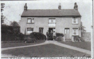
11. The Royal Oak. This was originally two cottages, but became a pub in c.1869, when the Woburn lawyer John Green purchased them. It would have been used by the Fullers Earth miners who worked on the Heath, digging the mineral by hand for the wool trade. Green sold out to Bedford brewers Newlands in 1877, but for many years it remained a simple ale-house with a beer-only licence.
When the houses to your right stop, there is an iron gate into St. Michael’s churchyard. Enter via this gate and walk through the burial grounds, staying to the left of the church. Beware some sharp-leaved plants! Please note: No dogs are allowed in the Churchyard. If you have brought your dog with you, please continue along the pavement to the main church gate.
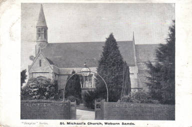
12. St. Michael’s Church. In 1865, Aspley Guise parish decided to form a new parish out of some of itself and Wavendon. The most influential supporters were William Denison, the churchwarden of Wavendon and John Vaux Moore, the Rector of Aspley Guise. The new parish needed a church so the 9th Duke of Bedford provided the land and financed the building. The architect was Henry Clutton of London and work started in 1867. The Consecration Service took place on 22nd September, 1868. It was enlarged in 1889 with seating for 100 more worshippers.
Leave via the main gates of the church, and turn immediately right, down the lane called Bishops Walk. N.B. There are some steep steps on the next part of the walk. If you would rather stay on level ground, turn left out of the gate here and descend Church Road the way you came. At the bottom of the hill, follow the pavement around the left hand corner and down into Hardwick Road. If you can navigate the steps, follow the dirt track to the end, past some houses, and into the footpath. This was known as Zig Zag Lane at the time of the 1881 census. After the steps, bear right, and in front of you is Hardwick Road. Please cross the road (which takes you back into Buckinghamshire) and turn right, walking a short way up the hill to:
13. Wesleyan Chapel. This was once a Wesleyan Chapel, until their new building was erected in the High Street in 1879. It was then sold off to Thomas Hudson, a local tradesman, who demolished the front part and converted the rest to a house.
Walk back down the hill to the corner opposite where you crossed Hardwick Road.
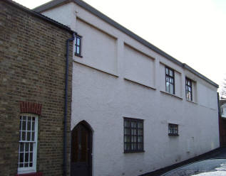
14. Friends Meeting House. This building was originally a Friends Meeting House used by the Quakers. It stands on the site of an earlier Quaker building (shown here) which has been traced to 1674, when the Quakers needed somewhere to meet without fear of persecution and prosecution. There is a large burial ground behind the building, where many interments have taken place, including Jeremiah Wiffen, the poet and his brother Benjamin Wiffen, the translator, as well as the How family of Aspley Guise. You can still see some of the gravestones behind the building, which is now used as a nursery. The burial ground was refurbished and a contemplative garden with sculptures and benches was created in 2023. You can see the garden by looking over the wooden gate that has been built into the wall and hedge as you walk down Hardwick Road. Access is restricted to key holders.
Cross Hardwick Road, and follow the footpath along the left edge of Mowbray Green:
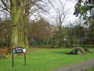
15. Mowbray Green. There was once an imposing residence here, called Hardwick House, another home of the Denison’s, but it was last occupied by the Mowbray sisters, Mary and Edith. After their passing, the house became uninhabitable and was demolished in 1962 to realign Hardwick Road. This park was opened in 1977 and is the location of the Millennium bandstand and the Holocaust Memorial. You can also see the distance that Greg Rutherford jumped for a Gold Medal in the 2012 Olympics (8m 31cm) as he lives locally.
On your left is:
16. Edgewick Farm. For many years a working small-holding, it was purchased by Woburn Sands Council in 2002 to protect it from development and is now open to the public. There are entrances at either side, but please be aware that animals may be grazing in the fields.
Continue around the edge of the Green, and when houses start again, the road straightens out in front of you, and you will see on the right of the road:
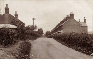
17. The Leys Terrace. These terraced cottages were built as homes for the workers in the local brickyards of Woburn Sands. The two larger residences at the far end, The Leys Villas, were reserved for the brickyard supervisors!
You will have just passed the end of cul-de-sac on the right on your way to see the Leys, return to it, and use this road to walk around the other side of Mowbray Green. Once at the other side of the Green, Chapel Street rises ahead of you. Walk up the left hand side of this road, past the period cottages. Once at the top, there is:
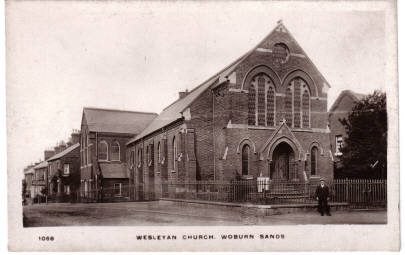
18. The Methodist Church. To replace the smaller one in Hardwick Road, this semi-Gothic styled Chapel was erected in 1879, built to hold 250 worshippers with 3 school rooms to teach 100 children. This was done on a budget of £1000. Once it was completed, the Ministers house beside it was commissioned. The names of those concerned with the building are recorded in stone tablets on the wall to your left.
Turn the left hand corner in front of the Chapel and follow the pavement to the end of the High Street, where it becomes Station Road. Carry on walking down into Station Road. This is the site of the:
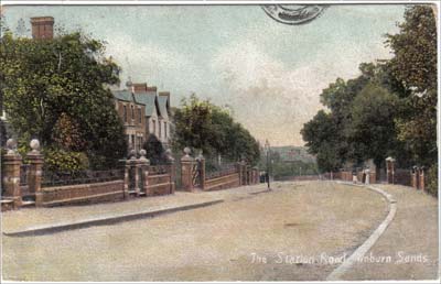
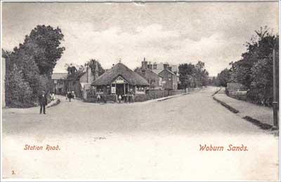
19. Station Road. In an 1858 book called “The Topography & Climate of Aspley Guise and their influence on Health and Disease”, Dr. J. Williams described how the local conditions were on a par with the best European spa health resorts. This, in combination with the coming of the railway in 1846 and the prosperity it brought to the area, meant it was an ideal location to have a grand residence built, to your own design, such as No.16, once the home of a ropeworks, or buy one from one of the speculative builders. Many of the houses are much the same as they were built 130+ years ago.
Cross over the entrances to Theydon Avenue, then Spring Grove, and continue. Just after West Road, opposite the fish & chip shop stands:
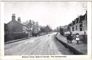
20. The Almshouses. The neat little Almshouses were built by Frederick Down, local entrepreneur, in 1902, but he died before they were finished. His business partner, William Needham, completed them and a period guide book described them as “…well-built with a sitting room, bedroom and scullery all on the ground floor… with a good garden. The tenant gets rent-free accommodation with a 5/- allowance for maintenance”.
Further along Station Road, the area on your left was once:
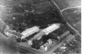
21. Industrial Works site. Originally several brickworks, a sawmill, blacksmiths and other small cottage industries occupied this site. The lakes in this area come from the excavation of clay. In 1947, James Summerlin and Rohan Sturdy brought their Plysu plastics factory here from Egham. The factory used to provide employment for local residents and the surrounding villages. This whole area has been redeveloped into residential use as Parklands, with a community hall, a newly opened Sport’s Hall and some plaques to record the past history of the site. It was in the brickyards in 1908 that George Smith attempted a heroic rescue of a colleague who had fallen into a hot brick kiln. Although unsuccessful, Smith was awarded the Royal Humane Society Stanhope Medal and the Albert Medal for his bravery.
Continue on the same pavement, and you will eventually come to:
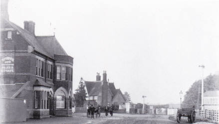
22. Station Tavern. In the 1872 Ale House Register, The Station is listed as only a Beer-House, which was first licensed in 1856. It was rebuilt in 1874 and was connected to the Goodall family for many years, who also owned the nearby sawmill. For the first 35 years, it was run by J. T. Luttman, who died at the Hotel in 1911, a year after his son had been killed in an accident on the railway.
& and across the car park is:
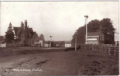
23. Railway Station. The arrival of the railway in 1846 really helped put Woburn Sands on the map. The scheme was backed by the Duke of Bedford and much of the local track ran on his land. He had wanted a station for Woburn, but the engineers explained that the hilly terrain made that impossible – the closest they could get was Woburn Sands. The line originally connected Oxford with Cambridge, but both ends were closed in the 1967 cuts, leaving the middle part of the line from Bletchley to Bedford. A rebuilt section of the railway from Bletchley to Oxford is under construction at present. The signal box was demolished in 2005 and signalling is now done remotely.
On the opposite side of the road stands:
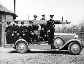
24. The Fire Station. The buildings opposite the Station were once used as a Fire Station. After closure, they were converted to a youth club in 1998 and remain as a community resource. During the conversion, a Fire Brigade Occurrence book for 1959-1964 was found. This showed the brigade toured the ‘new’ M1 motorway in 1959 to see how they would cope with high-speed traffic accidents. Many of the firemen worked in the Plysu factory opposite; hence one of the new roads there is called “Fireman’s Run”, as it was the route they took to the fire station when the alarm bell rang! The recreation ground beside the ex-fire station buildings stands on land that was awarded to the Surveyors of the Highway under the 1790 Wavendon Enclosure Award, to extract gravel for the upkeep of the road.
Trace your steps back up Station Road a short way to where the recreation ground is on the other side of the road. Cross over the road at the pedestrian crossing, and you are now in Bedfordshire again. Keep to this side of the road, and you will come to:
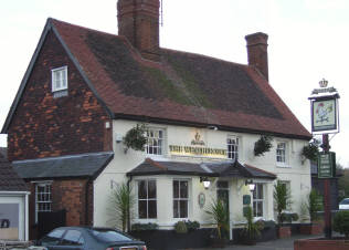
25. The Weathercock Inn. An inn called The New Inn is mentioned in the Wavendon church register in 1708 and in 1758 deeds about this site it was called The Thatched Inn, but The New Inn name appears again before the end of the 1700s. It later passed to the Orlebar family of Crawley House and then to the Hoare family of Wavendon House. Possibly the earliest use of the name “The Weathercock” came in 1791. The inn stands in Bedfordshire, but its bay windows were said to have overhung the border into Bucks. When mains gas came to Bucks first, before Beds, the landlord negotiated to have the pipe come into this window and have the meter there, so he could light the pub before his neighbours!
Straight ahead of you, at the junction of Weathercock Lane and Station Road, once sat:
26. The Cyclist’s Rest. A little thatched building was used as a café by cyclists, very popular in Victorian times. Sparks from a passing steam wagon in 1906 caught in the thatch and burned it to the ground.
Walk into Weathercock Lane as far as the turning for Burrows Close. Take the footpath opposite between the houses. This was originally a short cut from the main road to the windmill which stood nearby on land that is now used by Aspley Guise and Woburn Sands Golf Club. This footpath, which marks the county boundaries of Beds and Bucks, will bring you back to Station Road, and Buckinghamshire. Turn left and continue up Station Road, opposite to the way you came down it.
Among the large Victorian houses are:
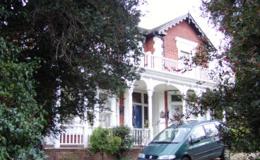
27. Station Road no.29 – Haydon House. This is an excellent example of the Victorian buildings along this road. It was probably built for Emma Down, the widow of Henry Down, the Woburn chemist. She and her sons, Henry and Frederick, prosperous local businessmen, were living there by 1877.
…and…
28. Station Road no. 11 – Sandymount. Charles Pole Stuart bought this empty plot in 1867 and built this large residence. At that time there was very little else built in the immediate area. The Stuarts were very much involved in the affairs of the town and he was a local magistrate for 37 years. It was here that the first recreational club met, the forerunner of the later Social Club. After transferring several times, the house was restored in the 1960s and became business premises. The site has now been converted back to residential use and another six large houses erected in the grounds.
Continue to walk up the hill to the corner of Russell Street becomes the High Street again. The wine merchants building on this corner of Russell Street was:
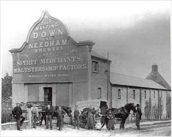
29. Down & Needham’s Eagle Malting. The Eagle Malting was the home of Down and Needham, maltsters, pub-owners, soft drink dealers and general businessmen. The partnership was formed after the death of Henry Down, when his younger brother Frederick needed a new business partner. They stood on just about every committee and group in Victorian Woburn Sands and employed many local people. When Frederick died in 1904, Needham inherited much of the estate. He was able to retire, periodically selling off the land and buildings, including a field where Downham Road now stands at the southern end of the town, which is a corruption of their two names. The original shop front has been built out from and the ornate signboard cut away. The original long malting building behind has been shortened and converted to houses.
Across the road is:
30. The Ironmongers. This shop has been an ironmonger for the whole of its existence since c.1880. William Needham started there, before joining Mr. Down at the malting across the road. Then it was held for many years by George Popple, who was said to be so lazy, that if he couldn’t immediately reach the goods customers asked for from where he was sat, then he would refuse to sell them! Gibson Andrews were an old established Woburn firm and their name has stayed with the shop even after it changed hands.
Turn left into Russell Street, and walk down to the half timbered building on the right:
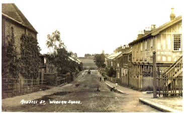
31. Russell Street was the first of the side streets in Woburn Sands. In 1870, the Higgins farm was sold off at auction. The buyer for the four lots of the Russell street area, which was just a field at the time, was William Milligan, a Dunstable hat manufacturer. He immediately laid out a road down the middle of his lots to join the High Street to Weathercock Lane and divided up the area into smaller lots. It is thought that Frederick Down had this building built, as it matched others in the district he commissioned. It was used for some years as the Woburn Sands Recreational Club and later a bakery and an antique shop, before becoming private residences.
Half way down Russell Street you will find the entrance to the car park, and you are back where you started.
We hope you have enjoyed this tour of some of the heritage of Woburn Sands, and come back soon to explore more of our town.
And finally, a few grateful “Thank Yous” …
Woburn Sands Town Council wishes to thank the following without whose hard work and assistance this work would never have been produced:
Paul Cox for all the historical research, most of the script and photographs.
Woburn Sands District Society, for some of the postcards and photos.
Cllr. Jacky Jeffreys for co-ordinating the original project.
Fulbrook Middle School, Year 7 Pupils 2007, for the front cover design of the original.
Milton Keynes Heritage Association for their generous grant which allowed us to provide a free copy to every household in Woburn Sands.
Northward Press, the original printers.
Jo Green for the updated version.
Justin Artingstall for the photos on the front and back covers of the updated version.
XL Press for printing the updated booklet.
Milton Keynes City Council for the generous grant to publish the updated version.
© Woburn Sands Town Council & Paul Cox 2024
Page last updated Jul. 2024.