
This page will gives a very brief overview of the history of our village, with some notable dates and events from the past. Whilst not a complete history, it will provide you with some background notes.
Woburn Sands stands in the north-east corner of Buckinghamshire, just outside the south east corner of the new city of Milton Keynes. Roughly, it stands with Bow Brickhill to the west and Wavendon to the north (both also in Bucks) and Aspley Guise to the east and Woburn to south, (both in Bedfordshire). How it came to be there, why it is called what it is called, and how it has developed is a complicated story!
There is history all around in Woburn Sands. As with everywhere else on this island, people have lived, worked, fought and died on most of its soil at one time or another, and even before man, far larger creatures stalked the vicinity. According to “A History of our District” by Aspley Heath School Historical Society, 1931, some vertebrae bones of a plesiosaurus were found in a Woburn Sands garden, and other dinosaur bones have been found in local clay pits. There are some excellent examples of other local finds in the Cowper Museum at Olney.
Human habitation of the district can certainly be traced back very far, with local archaeological finds scattered throughout the area. In 2000, a hoard of solid gold ‘torques’, or neck rings and bangles were found in Monkston, Milton Keynes, and dated from about 1000 BC.
Researchable history really begins with the Romans. The two invasions of Britain by Julius Caesar in 55 – 54 BC got no further than just north of St. Albans, but the next wave of Roman invaders came in 43 AD under Claudius. There followed an intense period of development in all walks of life; industry, farming, religion, townships etc. until the Celtic Britons revolted and the Romans withdrew in c.410 AD.
The most famous local site, Danesborough Camp on Aspley Heath, had three days of excavations in 1924 which led to finds that were attributed to no later than the second century AD. This was the Early Iron Age and Romano British, but whether there were pitched battles, with Roman Legions assailing the local Britons in the steep inclines of Aspley Woods, is lost in the mists of time. It is tempting to think of a last stand by the local tribes against the might of the Roman Empire. Certainly, Sir Frank Markham in his “History of Milton Keynes and District“, vol 1, 1973, believes that it could have been a base for tribes who were resisting the Roman advance.
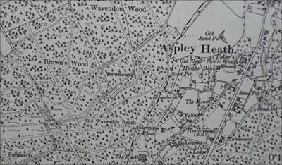
Danesborough is an 8.5 acre site, situated in what was marked as Browns Wood on the 1884 O.S. map, a name now familiar as a housing estate in Milton Keynes a mile or so further north. It is surrounded by the remains of a ditch and rampart which would have been as high as 20ft originally. The name is slightly misleading, as the Danes did not come in force until the 9th – 12th centuries. However, Bury or Burh is Saxon for “defended place”, and ‘Danes-‘ could be a corruption of ‘Don’, meaning Hill.
A local metal-detectorist found several Roman coins in the area. However, the Romans were eventually victorious, and Watling Street, part of the A5, serves as the main reminder of their presence in this district. Magiovinium was the name given to the local stopping point, and the name itself seems to have Celtic roots. This well defended station sat just south of Fenny Stratford. A horse station, now below the Tesco distribution centre, was discovered nearby, between Fenny Stratford and Simpson. There would have been Centurions travelling north to the “frontline”, with supplies to be taken up and plundered treasures transported back south again. There were older tracks crossing the Roman road, and any intersection is always a good place for a rest stop. There on the open flat land after coming northwards down the hill from the Brickhills would have been a pleasant spot, and the river was nearby for fresh water for soldiers and horses alike. Of course, Magiovinium was not the only local Roman settlement, and there are others over what is now Milton Keynes.
In ‘Roman Roads in the South-East Midlands’ 1964, it describes how there was a Roman cross-country road which dissected the modern Woburn to Woburn Sands road. Coming from Great Brickhill, it passes just to the north of Hundreds Farm and Longslade Cottage, crosses the Woburn Road just where the modern Longslade Lane meets it, and carries on roughly along Aspley Lane towards Crawley Park at Husborne Crawley. There is a small wooded knoll in the fields near Hundreds Farm still known as Tollhouse Grove.
Boudicca (and the revolt she spearheaded) travelled up Watling Street to take on the Roman Empire just north west of Towcester, in about 60A.D. But the rebellion was crushed, and some put the number of dead Britons at 80,000 to only 400 Romans. The defeated Boudicca poisoned herself and the Roman revenge and slaughter that followed is said to have left the whole area sparsely populated.
Once the Romans retreated to fight battles on their other fronts, there followed centuries of invasions by the European tribes. The Danelaw area of the 9th – 10th centuries came as close as Bedford, under which Danish invaders were given legal autonomy, and later ‘paid-off’ with Danegeld, but still returned to raid the Saxons lands anyway. It is possible that the Danes may have used the Danesborough hill fort, as this area lies close to the border with the part of England controlled by them, Maybe the Danes ventured outside their borders raiding, and took refuge in the ready-made hill fort. Again, the district seems certain to have been a stage to violent struggles.
The warring factions slowly made truces and pacts until eventually King Edgar ‘The Peaceful’ became the first King to unite English and Danes as fellow subjects, and also introduced a uniform currency.
In 969 AD, King Edgar granted 15 hides of land to a relative, Alfwold, in Aepslea (Aspley). The ‘Guise’ part of the name was still some time off. Other local place names mentioned in the document are Hysse Burn (Husborne), Woburn, Wafandun (Wavendon), Cranefeld (Cranfield), Mereston (Marston) and Holacot – (Hulcote). A full translation by the great Bedfordshire historian Dr. Fowler is reproduced in ‘A History of our District’. The area of a “hide” varied around the country, but was supposed to be enough to support one peasant household. One estimate for the eastern counties is 120 acres per hide, so this was a sizeable area. Alfwold was also free to leave his land to whomever he chose. Aspley already had its name, Aepslea, with a Saxon meaning of “place of the aspen trees”, Wafandun (Wavendon) came from Wafa’s Hill, and Woh burn (Woburn) meaning crooked stream.
There is some evidence to suggest that after the conquering Norman army in 1066 had crossed the Thames at Wallingford, the right wing of the army wheeled and passed through Buckinghamshire and then through Aspley and Ampthill, ready to attack London from the north.
Although by its name, Woburn Sands would seem to share some common history with the town of Woburn, it is actually closer in relationship with Wavendon in Bucks, and Aspley Guise, the tiny village just over the border into Bedfordshire to the east. Aspley is believed to be a Saxon village, which grew up around a spring in what is now the Square. The entry for Aepslea in the Domesday Book of 1086 records 25 families living there.
By 1286, the Manor of Aepslea was let to Anselm de Gyse, and the long association with that family completed the village name, and it became known as Aspley Guise. In the Inquisition of the Manor of Aspley in 1295, Fullers Earth is mentioned. This is the earliest recorded reference to the substance in Britain. Fullers Earth was used in the woollen trade to degrease wool before spinning, and the local variety was regarded as the best in the kingdom. It was mined perilously by hand, in bell-shaped pits, using the spoil from one to back fill the last. In 1720 it was noted that it was of such good quality that transportation of it was strictly prohibited. It was still mined until recently, in opencast mines, and put to slightly different uses.
Tudor and Stuart times in the area saw the manors pass from family to family, all with their fair share of intrigue and arguments, and the dissolution of the monasteries, when the last Abbot of Woburn Abbey was taken out and hanged for refusing to acknowledge Henry VIII in 1521. Shortly after this comes another mention of Fullers Earth, in a patent of 1539, in which Henry VIII granted the rights to one John Sheppard.
The English Civil War of 1642 – 49 had an impact locally on Woburn, particularly in 1645, when some locals exchanged shots with Royalists troops, and the town was attacked as a result. At least 27 houses there were burnt down and many others plundered.
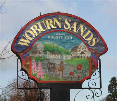
But what of Woburn Sands, and why has there been no real mention so far? The simple answer is that it did not exist, by that name, until relatively recently. Hogsty End was the term covering the area of what we know as present day Woburn Sands. This unattractive sounding End was one of several which formed the village of Wavendon, along with Cross, Church, Duck and Lower End. Wavendon can be found in the Doomsday Book too, a tiny band of farms and peasants. Obviously swine were farmed and probably the main piggeries were away from the church and populous centre of Wavendon. The most remote area of Wavendon was known as Hogsty End.
Anyone unlucky enough to lose their house or be evicted from Aspley Guise could have walked over the hill and taken some land on this area, as it was unwanted by anyone else. This was the crossroads between the tracks from Woburn, Bow Brickhill, Aspley Guise and Wavendon, so afforded the inhabitants the prospect of dealing of goods or services with travellers. The road from Hockliffe to Woburn was turnpiked in 1706, and this was extended through Hogsty End to Kingston Bridge in 1727. There needed to be toll gates and toll-houses for the collectors. It also meant stages would be using the better maintained road, and stages meant more travellers, who required more services. Inns would have sprung up alongside the road, with stabling, even though there were 16 inns in Woburn alone by 1823.
The first thing travellers would have seen as they struggled over the sand hills from Woburn would have been The Shoulder of Mutton Inn, on the west side of the Woburn Road, just before the main centre of Hogsty End. Once into the village, there was a large farm on the site of the Swan. In the 1700’s, most of Hogsty End was owned under two farms. These belonged to the Hart family, who had a homestead where Shelton House now is, and the Higgins family, based at the Swan Inn.
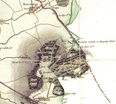
Jeffery’s Map of 1770, showing Hogsty End on the road between Wavendon and Woburn, at mile post 44 on the road from London. There are just a few scattered buildings detailed along the roadside. The mill is shown at the north of the village. The Society of Friends had established their Meeting House here in about 1675, and other early buildings were Inns. The Red Lion stood on the turnpike about halfway down our present High Street, and an Inn on the site of The Weathercock, had appeared about 1700, along with a few other scattered cottages.
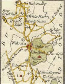
Interestingly, both names are given, “Woburn Sands or Hogstye End” in Bryant’s Map of 1825. Fir Tree Farm is noted just south of the main village. This farm had an inn, but it is not the pub we know today. It was an earlier version, which was previously known as The Greyhound, and The Shoulder of Mutton before that. It became the Fir Tree Inn in 1786. More buildings are shown now, with some extending along Hardwick Road towards Bow Brickhill. That was until the squatters moved in…
Aspley Heath was common land, and certain enterprising peasants carved off sections of it as their own. After a certain number of years, and with sworn witnessed attestations that they had held it from their fathers, the land became theirs. This was not without conflict with the local authorities, as can be imagined! By the early 1800’s, several such cases had been argued out, and gradually the Heath began to be populated, starting at the area around the Church Road – Hardwick Road corner.
The reason for the change of name from Hogsty End to Woburn Sands has been much debated. I quote from the late Arthur Parker, who lived and worked in Woburn Sands from 1921 to 1984, and was a respected local historian:
“There are many stories telling of the origin of the title of Woburn Sands, but I’m sure that that of Joseph Daniels carries most weight. He kept his school in the old building at the Swan, used for educational purposes, on and off, for many years; the building was demolished in 1960.
Over the door of the building was the sign “Woburn Sands Academy” and the reason for this is told by the old Aspley Guise Schoolmaster, James Mumford. He said Daniels found the name Hogsty End of no value to him, people not liking to send their children to school in such an unsalubrious place; so he decided to change its title otherwise he might be faced with financial loss.
So much for hearsay, but let me quote from a newspaper report of the laying of the foundation stone of “The Institute”, 1874; a person writing at this time might well have remembered Joseph Daniels and his school.
“Previous to about the 1820 this place was called Hogsty End. At about this time a Mr. Daniels kept an Academy about 150 yards south of this place. He had a large show board painted on it, “Woburn Sands Academy”; hence commenced the present name of this place.”
Joseph Daniels was evidently a man of some determination, after all he was a Schoolmaster, for having invented the title, he made sure that it would be used. In a deed dated 24th March 1812, covering the sale by Richard Higgins of Sherrington (owner of the Swan Inn and farm) to one James Young of the site of the cottage in Station Road, Daniels is brought in as mortgagee, description being “Joseph Daniels of Woburn Sands, commonly called Hogsty End in the parish of Wavendon Schoolmaster.”
I have examined hundreds a deed relating to local properties, and no where before the middle of the century have I found any reference to “Woburn Sands”. I am therefore satisfied that it is to Daniels that we give credit for the birth of the new name.”
However, I think this story may have a bit of Victorian romanticism. Daniels could have been the first to use the name for a commercial venture, but I believe it was well in use before 1820. Woburn Sands is used as the address for several of the subscribers to Dodds ‘History of Woburn’ in 1818. Further back, in 1785, Miss Orlebar, of Ecton, Northampton, had travelled though the area and recorded in her diary: “We enter on Woburn Sands, passing some houses, called Hog Sty Houses and formerly very properly so term’d; but the spirit of improvement has even extended to them: and they are now become neat little Public Houses: the once barrin hills of sand are now covered with flourishing plantations of Fir Trees…”
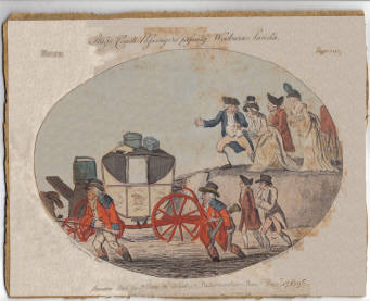
There is also an Issac Cruikshank etching used in “Eccentric Excursions or Literary and Pictorial Sketches of Countenance, Character, and Country in Different Parts of England and South Wales.” by G. M. Woodward, published in 1817, which shows a carriage stuck in the sand of what is believed to be the hill between Woburn Sands and Woburn (before the cutting though the hill was made), entitled “Stage coach passengers passing the Wooburn Sands Dec 17th, 1796”.
Then there is a letter written by J. D. Parry, a well-respected historian who published several works on Woburn Abbey and the Russells, in which the naming is discussed, and even the pronunciation of “Hog Sty End”. In the Gentleman’s Magazine of January 1845, in an article about Aspley Guise, he wrote:
“Partly in this parish, and partly in that of Wavendon, lies the hamlet of Hog’s-stye-end, containing about 300 inhabitants, a small number of respectable houses, and an ancient Quakers’ meeting-house, in a pleasant situation, of homely and dwelling-house appearance, said to be coeval with the rise of that respectable body. There is also a good inn, which has also been a boarding school, which, before the railroad days, had a considerable traffic. The hamlet stands on the old high road to Manchester, Liverpool, Chester, &c., which runs through Woburn and Newport Pagnell. The former interesting little town, well worth a visit, has also suffered heavily, like some others, from the “mammon” of railway speculation, now needing all the patronage and influence which can be afforded by the Bedford family, its natural protectors, some of whom have done so much for its ornament and benefit.
As, however, this name appeared cacophonous to its more polite inhabitants, attempts have been made more than once to “reform it altogether” to “Woburn Sands” or “The Sands,” and partly with success. Still: “Quo semel est imbuta recens servabit Testa diu;” [odorem* and “Hog’s-stye-end,” vulgarly dis-syllabled into “Hogs-teen’d,” yet lives.”
* “What’s bred in the Bone, will never out of the Flesh”
I believe both names were probably in use side by side for many years, with possibly the Woburn Sands name referring more to the southern end of the area where the majority of the fullers earth pits were, and Hogsty End to the northern end, where it was considered to be another “End” of Wavendon, along with Cross End, Church End and Lower End. I would imagine that it was the wealthier commercial traders who tried to drop the unmusical appellation first! There is a page elsewhere on this site devoted to the change of name…
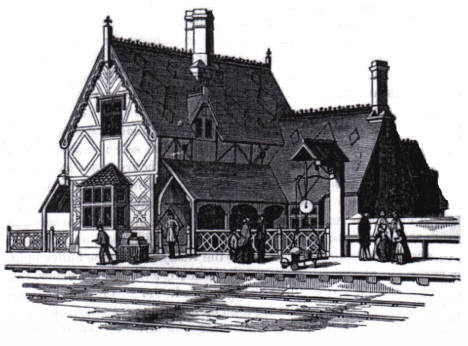
Whatever the real story, the area continued to attract new settlers and expand. One of the major turning points was the arrival of the Bedford – Bletchley Railway in 1846. The Duke of Bedford had supported the development, indeed most of the line ran on his land. Immediately, importing goods to the district was easier and cheaper, and the local trades of brick making and mined Fullers Earth could be exported around the country for the best price. The Duke had at first wanted his own station at Woburn, but the obstacle of the woods and undulating landscape meant the closest a station could be built was at Woburn Sands.
Around the crossroads in Woburn Sands, and the entrance to Aspley Hill, a commercial centre had grown up, known as Cheapside. Gradually the frontage plots to the main road became available, and tradesmen built premises there, or built out from existing homestead. The west side of the street was taken up with public buildings and the original Vicarage, therefore the commercial businesses spread down only the eastern side of the road.
In 1856, Dr. James Williams published a book called “The Topography and Climate of Aspley Guise, in Reference to their Influence upon Health and Disease.” In it, he extols the virtues of the local climate and shows how favourably it contrasts with well known European resorts. He had moved to the district for the benefit of his own health, and his reports did much to give the area a spa-like reputation, and the many convalescent homes set up on Aspley Heath owed their existence to this book. He mentions Aspley Heath, but regrets that it: “…has fallen into the hands of a distinct colony of independent settlers, who have erected tenements of some little value upon it, and reclaimed portions of the land from barrenness. It is to be regretted, from its great natural beauty, and proximity to the road and a first class railway station, that it has not fallen into other hands, and become the site of a better class of houses; such will, I have no doubt, be the case at no very distant period.”
Indeed he was correct, but most of the original poor squatter families were eventually bought out, and large imposing residences erected, most of which are still visible today.
There had come about a difficult situation of there being an unconnected island of land belonging to Aspley Guise and hence Bedfordshire within Wavendon parish, and therefore, Buckinghamshire. The reasons for this are lost in time, but it led to some difficulties as you can imagine. Most of the Heath belonged to Aspley Guise. These boundary confusions, of what exactly lay where, were only really sorted out once the ecclesiastical parish of Woburn Sands was laid out in 1865. This took in parts of both Aspley Guise and Wavendon, and St Michael’s was built in Aspley Heath, in Bedfordshire. By 1907, the town had become the tail wagging the dog of Wavendon, and a need arose to partition the villages, and a civil parish council was elected.
By now the golden Victorian age was at an end, but Woburn Sands profited from the industrial and technological advancements of the age. People were travelling more than ever, and the continued marketing of Woburn Sands as a health resort and holiday destination, along with easy access via the railway, brought day trippers flocking to the village at weekends and bank holidays. All these visitors wanted services, and the townsfolk were happy to take the money. Hotels, inns, guest houses, refreshment rooms, souvenir shops, and the like did a great trade. It is from this period that the majority of the postcards, ephemera and collectable china in my collection come.
The Great War ended this boom time, and the village was never the same again. New business came, and with them, different industries. In the Second World War, many staff from Bletchley Park were stationed in the town. After the war, the housing shortage meant new side roads were soon springing up.
In the late 1960’s, a new city began to be planned on the horizon. Soon, Milton Keynes was built and a huge population moved into an area which had been predominantly farmland. This development is still growing, and the latest plans bring it right up to the outskirts of Woburn Sands, the pretty little piggery…
That was a gallop through some of the main points of Woburn Sands’ history. Hopefully, it will provide some reference material as you explore the rest of this site.
Page last updated Feb. 2020.