
The Woburn to Hogsty End Toll Road: Over the Sand Hill
This analysis traces the route of the original Toll Road over the Sand Hill with the help of LiDAR mapping. Researched by Andy Mason.

When I first came to live in Woburn Sands in 1991, there used to be a different route over the sand hill between Woburn and Woburn Sands. This road was removed and realigned when the Fuller’s Earth extraction took place on the east side of the road. That’s all been well documented but in this research, I wanted to highlight and trace not only where that road used to run but also the original road and perhaps the pack horse road that ran before that. It all goes back to the mid- to late 18th century. Arthur Parker wrote up the minutes of the Trustees of the Toll Road and I found an interesting map inside his bound book. It’s on the library shelf in the Bucks. Archives.
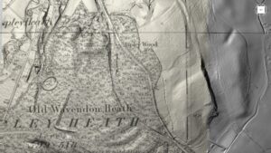
The following images are a combination of LiDAR, screenshots, maps, and overlays to highlight the results.
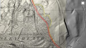
Below is the map in Arthur Parkers book which caught my eye. It came with an explanation that the Trustees of the Toll Road wanted to make new cuttings in the Sand Hill in order to ease the burden upon horse and carriage. In fact at one point in the late 1700’s and prior to the subsequent cutting through the sand, a license was granted for the use of 10 horses to pull a carriage. Yes, 10 horses!
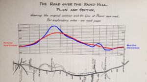
I’ve highlighted the existing (at the time) route and the proposal put forward to lessen the gradient by cutting the Sand Hill and creating a causeway to level the dips. The map along the bottom is a scaled drawing of the road and it is marked with positional contour heights above sea level.
The BLUE line is the cross section of the old road and here you appreciate just how steep the gradients were. Coming from The Birchmoor Arms the road went downhill over Preston’s Bridge before a steep incline over a hill before going downhill again as you approached Longslade Lane on your left. It was only then that you were faced with the huge Sand Hill gradient in front of you. Once you had surpassed that, the gradient downhill into Hogsty End was even steeper and the reverse journey could not have been any easier. You can imagine why 10 horses were needed at times when a heavy downpour turned the sand into a quagmire.
The RED line indicates the Trustees proposed new route to level the hill and improve the gradients in both directions. This was approved and this became the ‘new’ road that survived through Victorian times and became the road I remember in the 1990’s. However, this is not the route we know today. Of course, it was the Trustees job to raise the tolls and subsequently fund the road improvements.
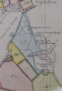
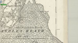
Above: An extract of the 1791 Enclosure Award for Wavendon (Hogsty End). Woburn Sands is at the top and the road due south east is the Sand Hill. Here the Pack Horse road is indicated along with the names of the various ‘woods’ on the very top of the hill.
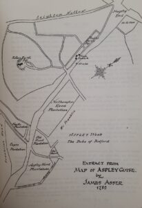
Above: This map was also in Arthur Parker’s Toll Road book. From 1782 so slightly before the Enclosures of 1791. The same wood names are given and the complexity of the junction is clear. The Pack Horse road is marked on this map as ‘Freeboard (cartway) in Aspley Wood’.
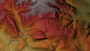
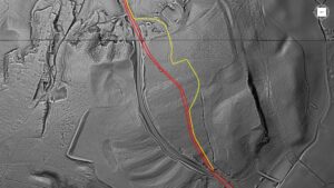
Referring back to the contour map with the red and blue gradients on the previous page, the Pack Horse road bypasses the highest point and may be the oldest of all the routes across the Sand Hill.
Historically it’s also the county boundary between Bedfordshire and Buckinghamshire and is shown as such on all old Ordnance Survey maps. Once the trustees made the new cutting, the Pack Horse Road became a narrow track and was only suitable for a cart, not a coach. Several decades ago, Beds. County Council filled in the Pack Horse Road and long before the Fuller’s Earth extraction started.
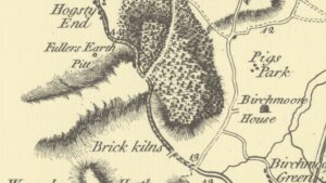
Below: An extract from Thos. Jeffrey’s map of Bedfordshire 1770 shows only the Pack Horse road and no cutting.
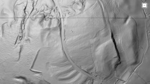
LiDAR: (LIght Detection And Ranging)
Modern digital mapping tools such as LiDAR can be used to accurately map the surface contours of the earth. Below is a very detailed and enhanced LiDAR scan of the Sand Hill route from Preston’s Bridge on the bottom left to Woburn Sands on the top right. This is a DTM model and has had all vegetation digitally removed.
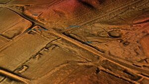
Preston’s Bridge & Longslade Lane
Arthur Parker notes in his book that at the time of the cutting (late 18th cent.) there would have been far more water flowing under Preston’s Bridge than there is today after a fall in the water table, with nothing more than a brook and culvert. This brook runs through to Husborne Crawley and once fed both Birchmoor Farm and Crawley Watermill.

Above: LiDAR image highlighting the first cutting made after Preston’s Bridge. Driving through this cutting today you can appreciate just how deep it is. The ‘pits’ for sand extraction are visible before the cutting and along Aspley Lane. This sand along with the cutting sand was used to level the gradients in both directions, lifting the road and creating a causeway at Preston’s Bridge and a further causeway beyond Longslade Lane as the gradient once again increased as the ‘new’ road went up and over the Sand Hill. Longslade Lane was also re-laid and straightened and sits on a new causeway. There’s a brook that runs in the wood alongside Longslade Lane and the area is prone to flooding in the winter. Long Slade refers to Old English meaning a Long: low-lying ground, a valley; a flat grassy area. Arthur Parker also noted that the junction of the turnpike road and Aspley Lane was created at the time of the cutting. Previously, it ran across the fields further up the lane and joined Birchmoor Green. Have you ever wondered why Birchmoor Green is a dead-end dog-leg leading to nowhere? It used to run diagonally across the corner to Aspley Guise and was probably cut off to improve the route and make sure all tolls were paid in all directions.
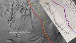
The Three Roads
The following images overlay on top of each other. The conclusion is an accurate map of all 3 roads and their relative position to today’s modern road.
LiDAR rendering enables modern features to be aligned with historical data and is a useful tool in ‘unpicking’ the layers of history. In this case, LiDAR gives us a sense of scale and purpose to the Trustees efforts to improve the road.
Today we take it for granted that our modern cars are capable of climbing and descending any hill but imagine the quagmire deep in the winter months that necessitated the need for 10 horses to simply pull a coach and its occupants just 1 mile. They also had to pay for the privilege via tolls.
The image below is a simple LiDAR overview of the area referred to as the Sand Hill. Both sides of this modern road have been excavated for Fuller’s Earth and have been returned to heathland. The scars are obvious. The approach to Woburn Sands is top centre.
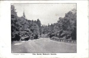
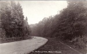
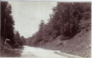
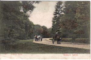
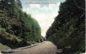
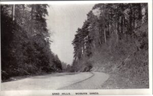
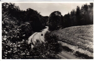
Postcard images of the Woburn – Woburn Sands road from early 20th century:
Acknowledgements:
LiDAR data source: Environment Agency National LiDAR programme, Open Government Licence
MAP: Ordnance Survey Map 1885 Six-Inch: Sheet XV Buckinghamshire: https://maps.nls.uk/view/102340115
PUBLICATION: The Woburn Toll Road – Arthur Parker L002 : Buckinghamshire Archives, Library Section.
POSTCARDS: Woburn Sands Collection
© Andy Mason, 2024.
Last updated Sept. 2024.